Thursday, February 28, 2013

Noosa Scenes

Hurray!  I got a few pics into the blog.  Along with the stormy weather we've had lately, the sea has been spectacular, with big swells.  Here a surfie is catchin' a wave at Noosa.

Alexandria Bay, a picture perfect beach in Noosa NP.  You can't drive here...it's an easy 2 1/2 km hike from the main carpark, or a hillier 1 1/2 km hike from my house to the south.  I've been coming here since 1988...or it it 1985?  Have to check my diaries.  I've always loved it here.

One of the common birds hereabouts is the brush turkey.  They quietly rummage about through the bush.

Monday, February 25, 2013

My Sunshine Beach Cottage


I am having trouble posting photos to the blog.  But this one got through...this is the lower level of my 3 level vacation home in Sunshine Beach.  This is one of my favorite places in all the world.  You have gorgeous, vast beaches; wild land preserved in a national park, within walking distance of the home; and the town of Noosa, Australia's version of La Jolla.  'nuf said.  The climate is like Florida.  I have loved this area since my first visit in 1985.  Now, every time I come I splurge and rent a fancy place...this is my second gig in this house.  The lower level is in the rainforest, as you can see here.  Mid level, with the kitchen and living room, is more open; top level has a view of the surf.  We've had a fine storm here today!  The rain has poured down in torrents, the wind howls, the sea is angry.  I cope by swimming laps in the pool in the rain...a rare treat for someone from Monterey, where it doesn't rain too often and it's cold when it does...here the temperature has ranged from 73 to 76 today.  Right now, 8 PM, it's 73 and the rain is coming down in torrents!  It's very cozy.  According to my makeshift rain gauge...a booze glass on the outdoor dining table...we've had about 4 inches today, and it's still piling up fast.

Thursday, February 21, 2013

A Quiet and beautiful land

I stayed two nights earlier this week at this classic Kiwi bach (pronounced batch).  This is a traditional New Zealand holiday home, typically in a beautiful setting in a very quiet area, cozy but a bit spartan...mine, for example, had no TV, internet, or cell service.  But the other modcons were all present, and the setting...well, check out the following pictures.

Here's the view from the deck of my bach. 

The afternoon I arrived it was gray, chilly, and windy.  But when I woke up the next morning, this was the scene I saw from my bedroom.

Sunrise over the Southern Ocean.  It's about 1500 miles to Antarctica.  Latitude is just a little over 46 degrees south...about the same distance from the equator as Astoria, Oregon.  But in this hemisphere, the only permanently inhabited land much farther south than this is in Chile and Argentina.

Lower McLean Falls, in the Catlins, as the region is known.  It's between Invercargill and Dunedin at the southern end of the South Island.

The main falls, reached by a hike through beautiful, primeval forest.

Matai Falls.

Hora Feliz at the bach.

Nearby is a haulout area for yellow eyed penguins.  Here, one bloke is waiting for his buddies to show up.  They come ashore at dusk and the tourons flock to see them...there were about a hundred of us and only three penguins.  They're shy...really.

Monday, February 18, 2013

Fiordland Scenes

The road to Milford Sound is a major scenic attraction in itself.  It goes through spectacular mountain country with many fine places to camp, but no towns at all.  This is cool forest viewed from the start of the Routeburn Track, one of nine New Zealand Great Walks that traverse the spectacular wilderness the country has to offer.

Approaching Milford Sound, you see towering, jagged mountains.  Some have small glaciers, but they are receding as the climate warms.  Blow up the pic and you'll see a glacier on the mountain to the right that's located on a rather steep slope...it will probably tumble down before the century is out.

The rainforest here is similar to that on the Olympic Peninsula in Washington.  Lush and otherworldly, a kingdom of green life.

Lake Gunn.

A massive red beech.  It does look like an ent!

This picture could be from Alberta, Montana, or Colorado, along the Front Range of the Rocky Mountains.  But, it's halfway between Te Anau and Milford Sound.  One thing I realized about New Zealand...it's one of the few countries...Switzerland is probably another...where every part is scenic!  Countries like Australia, Canada, and the US...all much bigger...have awesome beauty in many spots, but in other areas the landscape is dull and featureless.  Not so in NZ...it's gorgeous everywhere!

You drive through New Zealand and constantly come upon little gem spots like this one, where you can stretch, have a bit of a picnic, take a bathroom break, and just enjoy the beauty and the fresh air. 

Sunday, February 17, 2013

The Glory of Milford Sound

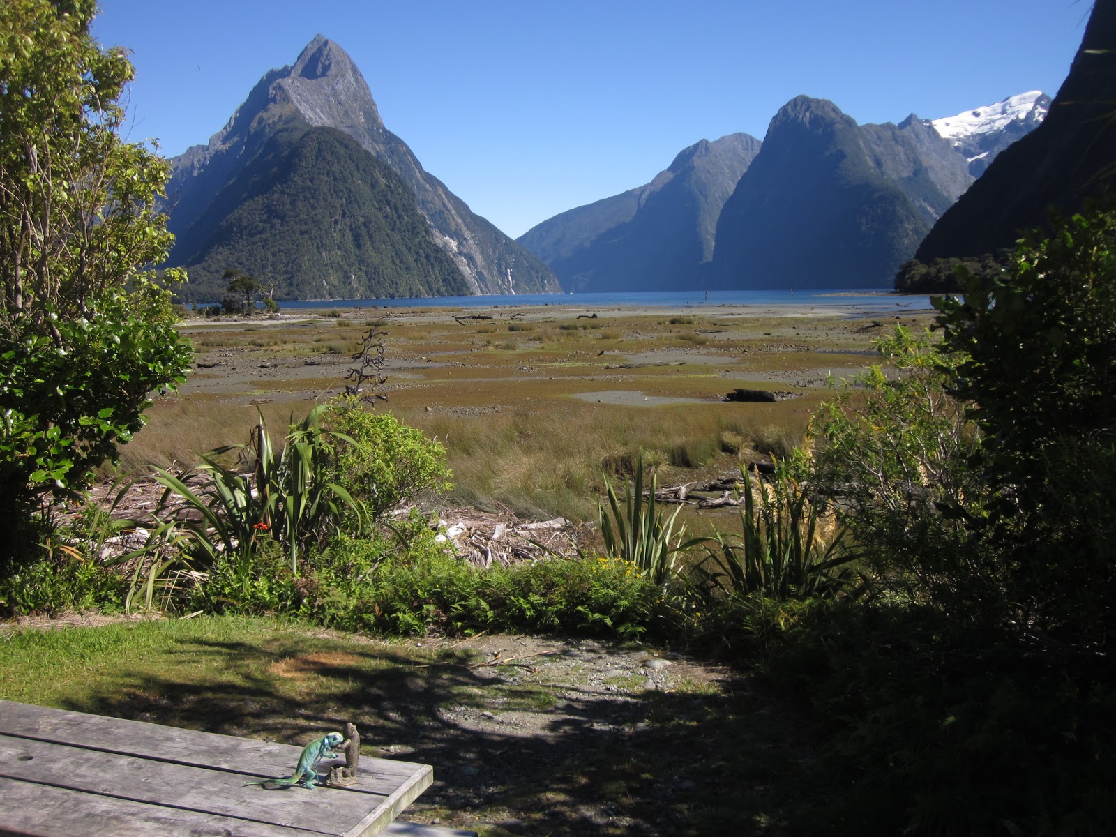
I visited Milford Sound today...a notch off my bucket list.  WOW!  The Lizards were out of their natural desert habitat, but I won the weather lottery.  I enjoyed a crystalline, sunny day in a place that receives 264 inches of rain a year!

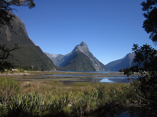
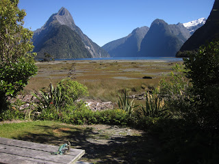
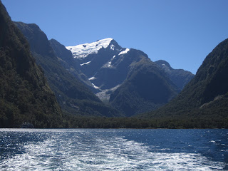
The Sound from land.  The arrow shaped peak in the middle is Mitre Peak, which rises over 5500 feet directly from the sea.

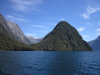
On the Sound.  BTW, it's actually a fjord, caused by glaciers carving a gorge during the Ice Age.  This was a nature oriented cruise, and our American accented guide explained geology, fauna and flora, and even meteorology of the sound to us. 

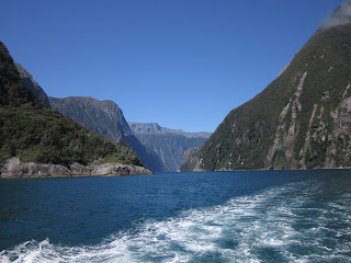
Looking behind.  Notice how CLEAR the air is!  It's been like that ever since I arrived in New Zealand.  Being islands, with no huge cities, and plenty of wind and atmospheric mixing, smog and even haze are not big issues here.  NZ has had other environmental issues, but air quality is not high on the list...it's great.

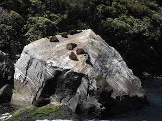
Fur sloats hanging out on a rock.  They pick windy spots to avoid the sandflies, which otherwise plague all beasts.  I have many sandfly bites as souvenirs...mostly around my ankles.  Damn bolshevik ankle biters!!

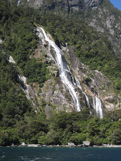
Sterling Falls, almost 500 feet high.  Our fairly small cruise boat was able to sail right under the falls!  The water just a few yards from shore is hundreds of feet deep.  This cascade is perennial, fed by glaciers on Mt Pembroke.  Our guide was kind of disappointed it hadn't rained much lately...when it does the sound has dozens of waterfalls like this one.  Today, only two...both glacier fed.

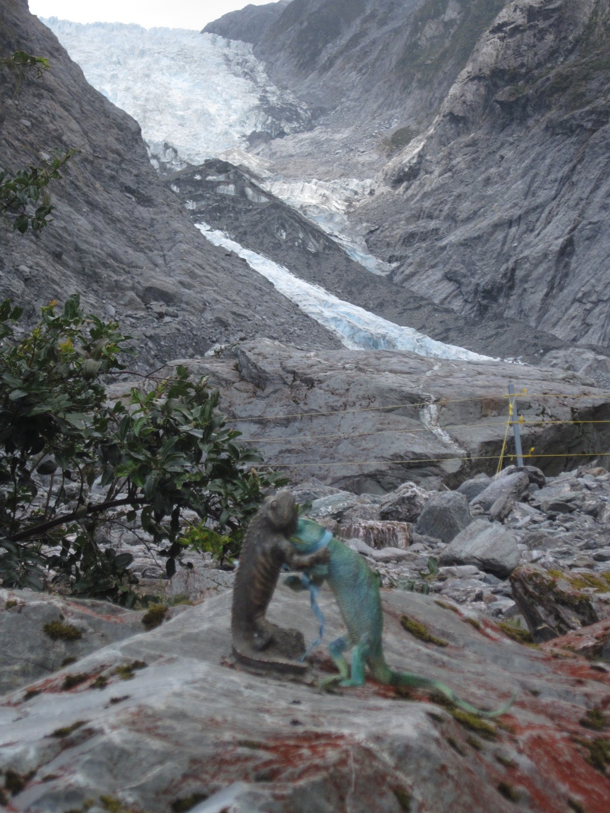
Here's Mount Pembroke, rising just over 2000 metres.  Our narrator saw a chunk of the glacier fall off earlier today...projections are for it to be gone in 50 years.  But it's still picturesque at the moment.  This of course is late summer in NZ, near the minimum for snow cover in the mountains.  In 4-6 weeks a new winter snowpack will begin developing.

This is the other perennial waterfall in Milford Sound, Bowen Falls...like Stirling, about 500 feet high.  I have many more pictures of Milford, and the mountain scenery enroute to the sound was also spectacular!  More posts coming.  I can only say that I cannot remember ever spending a day immersed in more natural beauty than today.  Cruising the inside passage of British Columbia is similar. Yosemite is similar.  Neither is better than this place...all three grade out at A plus plus.  It was a privilege to be able to see Milford Sound.

Thursday, February 14, 2013

Wanaka

Diamond Lake, near Wanaka.  For just a short, steep huff puff...only 400 metres...you can hike to this peaceful valley and see the mountains and clouds reflected in the lake.  A real beauty spot.

This is the view of Lake Wanaka from the middle of the town of the same name.  The resemblance to Okanagan Lake in southern British Columbia, and to Lake Chelan in central Washington, is amazing!  The climate and scenery are similar; wineries abound in all places; and they're all absolutely beautiful.  The woman who runs my motel has been to Lake Okanagan and she has the same impression.

A quiet valley near Diamond Lake, less than 20 km from Wanaka.  Great light hereabouts.

Mount Aspiring rises 10 thousand feet, showing glaciers while folks waterski on Lake Wanaka.

A Magic Forest of Ferns and Ents

Roaring Billy Falls by the Haast River.  I tried to load more pix but couldnt...will give it another shot later.

Wednesday, February 13, 2013

Franz Josef

Today I ventured south from Hokitika.  This is the Whataroa River, coursing through the Southern Alps to the sea.

I'm staying in the town of Franz Josef.  It's me and a ton of Brits, Germans, Chinese, and French.  Here we're all trekking to the snout of the Franz Josef Glacier.  This is a unique ice river.  At latitude 43 south, it descends to a little below 1000 feet elevation!  Nowhere else in the world does this happen.  It's possible because there are 12 thousand foot mountains, Cook and Tasman, just 20 miles from the sea...and the snowfields at the head of the glacier get up to 30 meters of snow...close to 100 feet...each year!  The snow solidifies into ice and plunges downhill at speeds up to 13 feet a day...this is the Usain Bolt of glaciers.  Of course, at these low elevations the glacier melts rapidly too...the Franz Josef has retreated at least a mile in the past 150 years, though there was a period in the 1990s when it advanced due to exceptionally heavy snow.

Blue glacial river water with a gnarly branch makes for an unusual picture...especially in the midst of a temperate rainforest.

Here's the glacier and its outlet stream.  My cabin is only about 5 miles from here.

Yes, the Lizards are doing the glacier!  However, they maintain that ice should be confined to floating in glasses where it can cool adult beverages.

This is the end of Franz Josef.  It took me awhile to realize this fact, but the big arch is actually dirty ice!  While high alpine glaciers are things of beauty, their snouts are usually scruffy, untidy, and not at all picturesque.  Blow up the pic and you can see a couple chunks of ice under the arch...showing why tourons are not permitted to approach any closer to the snout.  Icefalls are common there...especially in summer when temperatures are in the 60s and 70s.

A triple waterfall near the glacier.  The valley downstream from the ice is spectacular, with numerous waterfalls, blooming rata trees, and lush forest that makes an odd juxtaposition with the glacier.  It's like Kauai and the Canadian Rockies, in the same place!

Tuesday, February 12, 2013

Crossing the South Island

Earllier this week I traversed Arthur's Pass, crossing the South Island from east to west.  About halfway across I came upon Castle Hill, an area of bizarrely shaped rocks...karst limestone, to be exact.  You could hike among them, and they're popular with rock climbers.

At Arthur's Pass I did a short but steep hike to Devils Punchbowl Falls.  Well, that's the Pakeha name...the Maori name, Hinekakai, is prettier, I reckon.  Though the trail was only about a km in length, it involved climbing 261 steps...and, cruelly, when returning you had to climb 74 more while descending the 261.  Wheels were shot after this trek.  Lots of gnarly trees in this area...mainly southern beech.  If you think some of these trees would make good ents, well, Lord of the Rings and The Hobbit were filmed in New Zealand, after all.

The wispy bottom of Hinekakai Falls.  At 131 metres high, it's quite substantial.

Now we're descending from the 900 metre summit of Arthur's Pass.  This is the Otira Canyon viaduct, quite an engineering feat, and beautiful.

A patch of the local wildflowers.

Rata trees are blooming on the mountainsides of Arthur's Pass, dappling the heights in red.

Anyone who has been to the coast of far Northern California has seen the vast gravel riverbeds.  They occur in areas where the normal flow of a stream is small, but massive floods completely submerge the river valley often enough to preclude much vegetation growth.  Many of the river valleys in the Southern Alps are even vaster than those in Cali!  It must be quite a spectacle when these are filled with water.  Probable scenario would be the same as in Nocal...a warm, wet rainstorm melting a deep snowpack.

Heavenly Hokitika

Hokitika...what a beautiful name for a cool beach town in a gorgeous part of the world!  It's at the same latitude as southern Oregon, and the coast is similar in appearance and climate.  A delicate beauty prevails.

The locals have used some of their driftwood to construct whimsical sculptures at the seashore.

A little civic pride here...blow up the pic and it becomes evident that the wood spells HOKITIKA

Yeah, for sure!  Sign in downtown Hokitika.

This is Hokitika gorge.  Wow!  The turquoise water is colored by glacial silt from the nearby Southern Alps.  I've seen rivers of this color before, but they were in Canada, in alpine settings.  To see this water color in a lush, green temperate rainforest was stunning!

A swinging bridge spans the gorge.

Strolling the beach in the evening (sunset around 845 PM) I came upon this stump...looks like a tree grew on the spot long ago...probably not.  But the effect is a bit surreal.

Another shot of the gorge...too lovely!

I'm staying right on the beach in one of the duplex cabins behind our Simmental neighbor, who is enjoying a dinner of fresh green grass.