Sunday, August 26, 2007

Wild Wild West


Here's a shot of a truly motley group of desperadoes. Our posse blew into Trail Dust town and had quite a time for awhile. Unfortunately, we got caught cheating at cards; we drank all the whiskey; I fell on the piano during the obligatory brawl and knocked it out of tune; and we made a couple of bad weather forecasts (four of us are meteorologists), and the sheriff finally kicked us out of town. But we had fun while we were there!

Saturday, August 18, 2007

A Granite Wonderland


I crossed Yosemite via Tioga Pass today. This route passes through spectacular granite country. Geologically speaking it is just beginning to be revegetated since the Ice Age glaciers swept it clean and scoured it smooth. One of The Old Sloat's preferred pastimes is granitic slotation (also known as granite vegging), which consists of finding a nice smooth piece of granite, lying down, soaking up the sun, reading a book, and taking a siesta. All were accomplished very nicely today in Yosemite. I'm always impressed with the tenacity of the vegetation in granite country; here a couple of small trees are growing in tiny patches of soil in the seams between the granite. Not only do these trees have very little dirt to work with, they also have to contend with five months of winter and a summer drought. But they do.


When driving the Tioga road, I always stop at Tenaya Lake for a little granite vegging. I first found the lake thirty years ago, when I camped there for a few nights, hiking in the surrounding wilderness during the day. The campground is long gone, but there are still fine picnic grounds, and you can either lay out on the granite or...on beaches! Yes, in the heart of the Sierra, 8000 feet above sea level, there are sandy beaches on Tenaya Lake. It's really a fine spot.


Yes, here in the Yosemite high country we are back in glacial erratic territory. These isolated boulders are found everywhere sitting on the granite, where a glacier deposited them thousands of years ago. This particular rock is a little smaller than a smart car; there are many stones larger than this one. By the way, notice the brown grass in the meadow. It's been drier than normal here, starting with the driest winter in a decade or so. A plus is that there are no mosquitoes.


Mono Lake


Mono Lake is a desert sea east of the Sierra. Since the water is 2 1/2 times as salty as the ocean, I hesitate to call it an oasis, though the migratory birds that hang out there enjoy it. At any rate, it's rather a bizarre place with the tufa towers (calcified limestone created by underwater springs) , billions of brine flies (who don't bother humans) and the unusual natural setting...desert surrounded by towering mountains. The lake is much lower than it was 70 years ago, as the city of Los Angeles began siphoning water from the creeks that drain into the lake. By the 1980s the lake level had fallen over 40 feet and the ecosystem was crashing. For example, the water level dropped so low that islands that had been nesting sites for thousands of birds were connected to land, enabling predators to prey on the birds' nests. Fortunately, conservationists got together with the LA water people and worked out a compromise where the lake will be raised about 20 feet from its lowest level...enough to preserve the ecosystem but not so much as to significantly reduce water supplies to LA. So, currently the lake level is rising and will rise another 10 feet or so in the next decade, weather permitting.


The deep blue water in the middle of the desert combined with the gnarly tufa towers have made Mono a rather surreal place for decades. For example, one of Pink Floyd's albums from the 1970s, Wish You Were Here, included a postcard of the lake with the record. The visible tufa towers are a legacy of the previous higher lake levels; when the towers are actually forming, they are completely under water.


The Lizard thoroughly enjoyed his visit to Mono Lake. In addition to liking desert environments, he's always up for unusual scenery.

American Outback


Yesterday I drove the Extraterrestrial Highway across south central Nevada, bound for Tonopah.

It goes across country about as empty as it gets in the lower 48. In 100 miles there is one (1) tiny town; one (1) mom 'n pop gas station which I'm not sure was open; a few farms; and several billion sagebrush plants. Basically, there ain't nothin'. The wind was relentless across the highway; here it's raising dust from a dry lake bed. In the 100 miles I encountered perhaps 15-20 other cars, most traveling in two vehicle convoys. This is probably not a bad idea considering the ultra-isolation of the area. It did remind me of the Australian outback. Incidentially, I should update the intro at the top of the blog. I have now visited Tonopah (bleak and godforsaken but with friendly people) and Portland Maine (very nice in September but I wouldn't want to be there in the winter).

Friday, August 17, 2007

More Bryce Shots


Here's a row of fins at Bryce (this post should probably have been entered earlier, putting it below the previous one). The fins are caused by erosion, mostly by rain and the freeze thaw cycle, which occurs about 200 days a year here; the erosion processes separate harder rock from softer material, and wedge similar pieces of rock apart when water freezes and expands as it becomes ice. Further erosion will divide the fins up into individual hoodoos. The pine and fir trees nestling between the fins add contrast to the scene; I'm always surprised to see them in what otherwise looks like a desert environment. Bryce is quite dry as only 15-20 inches of precipitation fall per year, but its elevation of 7500-9100 feet keeps temperatures cool, allowing the conifers to thrive.


A wider shot of the fins above reveals a couple of windows in the rock to the right. No, Bill Gates didn't invent these particular windows, they're just another byproduct of erosion.


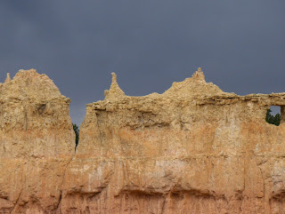
This is a skyline shot as a thunderstorm approaches. I had hiked a little way down into the canyon when I took this picture. Would have gone farther, but aside from The Lizard the other thing I forgot to take along on the trip was an umbrella! Notice another window on the far right.

Photographers Paradise


I visited Bryce Canyon NP for the second time...the first was back in 1988. To put it simply, I know of no other place so conducive to photography! Some national parks, like Yosemite and Grand Canyon, have grander, more overwhelming landscapes; others, like Olympic and Everglades, preserve more interesting ecosystems. But no place anywhere has more spectacular colors and landforms than Bryce. It's just mindboggling. Every place you look, every time the light changes even just a bit, you get a new perspective.


The dominant rock formations in Bryce are the towers called hoodoos. These are made of limestone, which is naturally gray; minerals in the rock add the colors. Only a slight difference in hardness of the rock will cause different erosion patterns on adjacent landforms, and the result is magic.


Once again, I got lucky with the weather from a photographers standpoint as there were numerous thunderstorms both days I was at Bryce. The black clouds enhanced and brightened the colors of the rocks; the effect was breathtaking.


This picture covers most of the scene portrayed in the photo directly above it; but without any sky, it looks more like abstract art than landscape. Bryce is surreal!! You could shoot a thousand pictures in a day and not get two that are alike.

The Lizard Does Bryce


Yes The Lizard did make this trip...at least most of it. Actually, I forgot him when I took off; I reached Gonzales before I realized this grievous error, and phoned Brooke, who graciously brought him along when she flew in a couple days later. Here The Lizard is at Bryce, marveling in the hoodoos. The Lizard loves the desert as I have said before, but even he was enervated by the heat in Phoenix.

More Monsoon Weather


Watching a thunderstorm from the north rim, , I noticed this curved rain shaft. Think there's some wind with this storm? Yep. Downburst city, baby! (Apologies to Dick Vitale).


I found this little patch of hail a bit inland from the north rim. I missed this storm personally; I was a few miles to the south when it hit. Just small pea sized stones.

North Rim Splendor


I stayed at the north rim of the Grand Canyon for two days. It was only my second visit to that rim...the first was in 1975, so I was due for a return trip. I've been to the south rim 6-8 times, something like that. Though it's busy right around the village where the cabins and restaurants are located, it's easy to get away from most of the people and overall the north rim is much quieter than the south...it receives only about 10 percent as many visitors. Like the south rim, the rock formations and colors are fantastic, and they change constantly with the angle of the sun and the weather. August is a particularly good time to go as the monsoon thunderstorms really accelerate the changes in the canyon scenery.


Here the afternoon thunderstorms are firing up. They're spectacular; lightning flashes, thunder rumbles through the gorge, and of course the light changes every minute. I found myself a good spot near the rim, and enjoyed listening to the wind whistle through the trees around me as I gazed out over the canyon. Fine sensations of peace and grandeur. However, such a vantage point must be chosen carefully; you don't want to be alone out on the rim with no shelter, and you don't want to be under the tallest trees in the area, as these spots are where the lightning usually strikes.


I just liked the colors in this picture. The canyon is most luminous at sunrise, sunset,and when there are a lot of clouds around to create a complex light pattern.

Wild Arizona Weather


I pulled into my friend Dave's house in the Phoenix area last Sunday (Aug 12). It was, uh, a bit on the warm side. This is the thermometer on Dave's patio. It's always in the shade, but heat radiates off the patio, making the reading a little high according to Dave. Sure enough, while this thermometer says 116 degrees...it eventually topped out at 120...the official high at the airport was a mere 114. It was so hot that when I breathed through my nose, my nostrils burned! I went for a spin to run errands around 830 that evening...it had already been dark for an hour...and it was still 106. But...by dawn the mercury had plunged to 91. I went over to the fitness club in Dave's complex to cool off with a swim in the outdoor pool, but with the ongoing heat the water temperature was close to 90. It's serious hot in Phoenix during the summer!


The following day I headed for the north rim of the Grand Canyon. The heat was left behind as I climbed to Flagstaff, 7000 feet above sea level, but a different weather concern arose, in the form of a massive thunderstorm that brought biblical downpours and some small hail. Water was running through the Ponderosa pine forest everywhere! This is a pic of the mammatus clouds on the underside of the CB (cumulonimbus cloud) after I had escaped to the north. One good byproduct of driving through the storm was that my car was clean as a whistle afterward!

Sunday, August 12, 2007

Classic Arizona Sunset


At the end of the day, after a thunderstorm, the mix of clouds of all shapes at all heights produced a quintissential Arizona sunset. I discovered the "sunset" feature on my camera just in time, and broke out my tripod for the first time in about 20 years to get these shots. Oughta do that more often.


More Thunder on the Horizon


Yesterday I beat the heat by driving to Mount Lemmon, in the Catalinas over a mile above Tucson. It's a different world up there, with pine and even Douglas fir forests and pleasant, cool air. In winter of course it snows; there's even a ski area there, only an hour from the city. Here's a nice developing CB, as we weather guessers call cumulonimbus clouds. CB's easier to say, I reckon.


Back on the valley floor, a bigger CB loomed to the south, with mammatus clouds, the lumps visible in the middle of the picture. They show up better when you blow up the photo. They indicate a very strong storm. This one missed us to the southwest, but we did get a brief thunderstorm at the Westward Look later.

Friday, August 10, 2007

The Monsoon Strikes!


The monsoon hit Tucson early this evening; about 6 PM a massive thunderstorm kind of moved in from the east and blew up at the same time, bringing sheets of rain, frequent flashes of lightning, crackling thunder, and howling winds. A fine storm! I of course enjoy thunderstorms much more when I am watching them than when I was working them at the weather office; you're too busy to enjoy the storm in that situation.

This picture was taken on a nature trail on the grounds of the Westward Look. The little arroyo at the bottom of the canyon was actually flowing...first time I've seen water in it. Not exactly a flash flood but significant. The area was under both severe thunderstorm and flash flood warnings during the storm. I put the Lizard outside to do storm duty and he measured about half an inch of rain in 45 minutes...not biblical but a respectable soaking.


In the gloaming at sunset, after the storm, a refreshed saguaro reaches for the sky. The cactus stores water in its interior and will weigh several tons after a good downpour.


On the nature trail, I came upon this lone flower on a cholla cactus, blooming several months late. The desert is full of surprises; plants, animals, weather, waterholes, etc. It's often harsh, but always beautiful and endlessly fascinating.

Sabino Stomp


Today I hung out in one of my traditional Tucson hangouts...Sabino Canyon. It's a gorge in the desert just northeast of Tucson. Though it's a desert ecosystem, Sabino Creek usually flows because its watershed is the Catalina mountains, 9 thousand feet above sea level; the creek gets runoff from snowmelt in the winter and spring and from frequent thunderstorms during the summer monsoon. You can even find pine cones near the creek, carried by floodwaters from thousands of feet above. At this particular spot I sloated out for awhile, reclining in the creek in the shade. Very pleasant.


The creek was running robustly today, but has been much higher in the past few weeks when torrents of rain drenched the area. Evidence of these floods is everywhere, like the twigs wrapped around this tree, several feet above the current waterline. The shuttle bus only goes halfway up the canyon; road damage dating from last year prevents it from making the entire trip.


The creek crosses many bridges, all of which were underwater today. I got my feet wet repeatedly, but when the temperature's in the 90s, this is no problem.


The sides of Sabino Canyon are covered by a particularly luxuriant saguaro forest. The combination of cactus on the slopes and cottonwoods in the canyon, with a refreshing creek, make Sabino one of the premier desert oases found anywhere!

Bisbee


We went to Bisbee to visit Brooke's sister Amy and check out the town; neither of us had been there before. It's a historic mining town and also a countercultural haven. And, they've had a minor league baseball team for many, many years and have the oldest stadium in use today, though it's been renovated. A very cool place!


Several of us toured the Copper Queen Mine, which produced huge amounts of ore until it closed about 30 years ago. There's also a huge open pit copper mine in town. This pic shows a lode of copper...the green rock...and lots of funky coloration. This picture was taken hundreds of feet underground; you ride a little mine train on the tour.


Here's one of your typical tough ol' hardrock miners; well, OK, it's Brooke. She looks good in a hard hat! The temperature in the mine was about 51 degrees and all of us who took the tour were issued slickers, hard hats, and lights with a battery pack. What a tough job it would be; underground all day, chilly and damp, hard physical work, dangerous, and from what our guide...a retired miner...told us, the pay wasn't great.

Stately Saguaros


Tucson is the home of the saguaro! They grow more densely and larger in this area than almost anywhere else. The saguaro normally blooms in May or early June, but there are a few late flowers around; the recent rainfall probably helps. The saguaro is Arizona's state flower.


I may have blogged a picture like this last winter, but the ridges, valleys, and spines of a saguaro up close are surreal. There's a picture similar to this one in my hotel room at the Westward Look; but this is my own photo. The desert around Tucson is a paradise for nature photographers!

Monsoon Blooms


I'm currently in Tucson, checking out the monsoon. It's been an active one this year; Tucson had over five inches of rain in the last two weeks of July. As a result, the countryside is verdant; the greenest I've seen since the El Nino of 1983-84. And that was in the spring, not in August. The rain has helped some of the cactus to bloom; here's a little cholla showing flashy large magenta flowers.


The barrel cacti are the stars of the show right now. Lots of them are blooming; from what I read they normally bloom in summer rather than spring, and the monsoon moisture is sure helping them!


The symmetry of many cacti is fascinating, and gorgeous. Here's a barrel, looking down from the top.

Sunday, August 05, 2007

Victorian Beauties


It occurred to me recently that I have been blogging for over a year, and have never blogged San Francisco! This is a gross oversight...I live only 120 miles away...and I set out to correct it recently. The City of course has many unique elements; its cultural diversity; great food; awesome scenery; a lively history; a cutting edge arts scene. And...the architecture. It tends toward the eclectic; all styles are represented from the mid 19th century to the present. Though the 1906 earthquake and fire destroyed much of the city...over 400 blocks...some survived. The home in the center of this pic, in Pacific Heights, is a superb example of Italianate architecture from the 1870s/80s. It's been lovingly restored. The house to the right, partially obscured by a tree, has not been treated the same; its Victorian facade was replaced by...shakes! Such architectural abominations were unfortunately common in the 1950s and early 60s.


The massive home on the left side of this pic is Queen Anne style, popular in the 1890s. This style is characterized by circular towers. Very cool, but I bet the curved windows are costly. Mansions have always been part of the San Francisco scene. The city first became prominent during the gold rush around 1850, and from that time onward San Francisco has tended to attract people probably more adventurous than most; more willing to take risks; and more willing to live it up when hitting it rich. That spirit has remained, from the 49ers to the dotcommers. They live in places like this.


It's neat to prowl around the Victorian neighborhoods and check out the cool woodwork. They don't do much stuff like this anymore. This panel is on the Queen Anne pictured directly above.

More architecture


The house in the middle of the picture is a classic Stick style building, with the bay windows squared off. These date from the 1880s, give or take a decade. To the left is a Queen Anne home, with gables and a turret just visible; these were popular in the 1890s. Like other homes in Pacific Heights, these Victorians survived the 1906 fire; the fire burned as far west as Van Ness and in some places to Franklin Street, one block farther west. These homes are a few blocks west of that.


The home in the middle of this pic is a typical Mediterranean style, probably constructed in the 1920s or 1930s. This pic is taken on the lower slopes of Russian Hill, where the fire burned most structures in 1906 (but not at the top of the hill; see the next post).

City Scenes


I've enjoyed this scene of The City ever since I was in college. The pic is taken from Russian Hill, in Ina Coolbrith Park, with the Transamerica Pyramid prominent. This spot has a history from the 1906 quake and fire. A house just to the right of the picture was threatened by the flames spreading up the hill; the owner raised the American flag, the firefighters saw it, rallied round, and saved the neighborhood atop the hill while flames consumed the entire surrounding area. So, you can still spot some 19th century building on the hill while everywhere around the area features early 20th century architecture.


This picture is taken from the top of the Lyon steps, at Broadway on Pacific Heights. There are a fair number of streets in San Francisco where the grade is too steep for a roadbed, so the street is merely a staircase for a few blocks. These are hidden gems in The City, usually beautifully landscaped, islands of tranquillity in the urban environment. Pacific Heights is not a sketchy neighborhood. Folks like Dianne Feinstein, Robin Williams, and Danielle Steel have homes here.