Thursday, August 29, 2013

The Magical Hoh

Yesterday I visited the Hoh rain forest in Olympic National Park.  I first saw this place about 50 years ago on a family vacation, and even as a kid I remember being amazed at the lushness and beauty.  It remains wonderful and mystical.  On a balmy, humid day, mists rise above the river and cloak the hills.  Everything is soft, all lines are rounded.

Sitka spruce trees tower in the rainforest, nourished by 140 inches of rain a year.

This is nurse log central!  These four trees started out as saplings growing on top of a log, which provided them nutrients as it rotted.  Eventually, the saplings grew larger and sent roots down the log into the soil.  When the nurse log finally disappeared, this scene is what was left.

The Hoh is a kingdom of moss.  It cloaks everything.  The myriad moss formations and the soft, changing light make the Hoh valley a fantasy world.

The forest floor presents fine patterns of vegetation.  Elk keep it fairly well groomed by chomping the vegetation down.

Fungus also finds a congenial home here.

Mist drifts along the hillsides, day after day, nourishing and shrouding the trees.

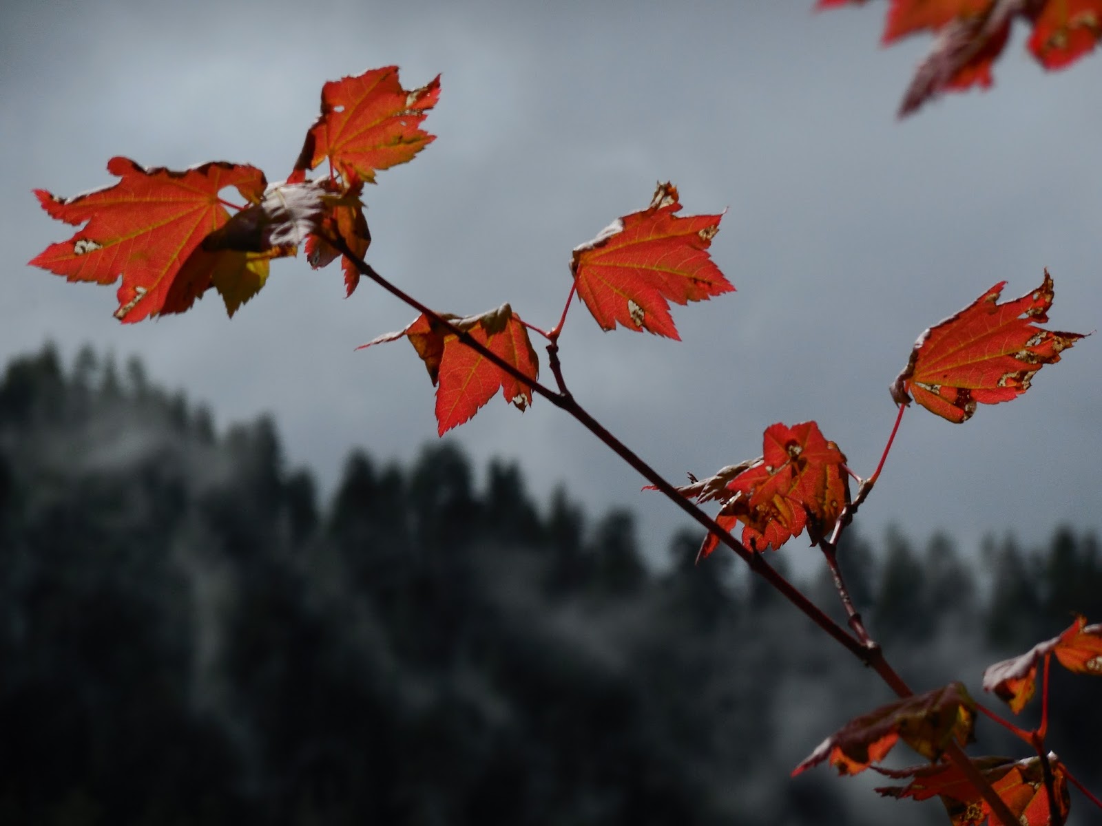
At the end of August, a few vine maples are already changing color.  There are many maples among the spruce and hemlocks, and by October they'll put on a nice color show.

A banana slug cruises the trail.

Wednesday, August 28, 2013

Western Washington Land/Seascapes

I've been roaming around Western Washington the past few days.  There are innumerable beauty spots.  Most involve water...either on the ground, on ice, or falling from the sky.  Here, in the North Cascades near Wallace Falls, moss is king.

The trail to Wallace Falls is just off highway 2.  There are several finely built bridges along the way that blend nicely with the forest.

On the ferry from Edmonds to Kingston.  This seagull hitched a ride for awhile.

A sailboat (under power) glides gracefully through Puget Sound, with the Olympics in the background.

A tug tows a barge, with a freighter in the background and the towers of downtown Seattle in the far distance.  Urban and natural settings blend nicely in Puget Sound.

This pic was taken from Hurricane Ridge, in Olympic National Park.  I've been up here at least three times, but possibly not since college, 40 years ago.  There's a visitor center here, a mile above sea level, deep in the Olympics.  This shot shows Mount Olympus, its summit shrouded by clouds, and the Blue Glacier.  In this northern latitude, with tremendous winter snowfalls, glaciers extend down to less than 7000 feet above sea level.

Subalpine firs, mountains, and glaciers.  To me, the Olympics have always seemed exotic and mysterious.  For starters, those of us who live in the I-5 corridor...or west of it...are accustomed to seeing snowcapped, rocky peaks to our east...Cascades or Sierra.  The Olympics, instead, are to the west of Seattle, toward the sea.  No roads pass through them.  They were not traversed by contemporary people until the last decade of the 19th century.  Still, a weeklong backpack is necessary to pass through the range between Puget Sound and the Pacific.  And they're magnificent...wild, rugged, untamed. 

Deer at Hurricane Ridge are accustomed to tourons.  This one strolled nonchalantly past us.  Another deer walked with me, about 15 feet away, as I moved along a trail.  But give them credit...they didn't beg!

Farther along my route, I stopped at Lake Crescent, in the park along highway 101.  Created by glaciers, I have always loved this lake.  It's gorgeous and peaceful.  On the common gray days, it broods in a most tranquil manner.   

Wednesday, August 21, 2013

Central Oregon Volcano Action

Central Oregon is a land of endless diversity and fascination.  Sculpted by volcanism, the landforms are beautiful and bizarre.  This lake is near Mount Bachelor.

South Sister looms over farmland near the town of Sisters, a former farming outpost turned swish and chic.  The volcano erupted until about 25 thousand years ago.

This lava flow surged through McKenzie pass about 3 thousand years ago.  Belknap Crater, in the background, was responsible for some of the lava but other sections of a'a originated from other vents nearby.

Mount Washington looms over vast lava fields and dead forests.  The trees somehow eked out a living as patches of soil drifted into the lava, then succumbed to harsh weather, insects, or both.

A kipuka near Belknap Crater.  Kipuka is a Hawaiian term that has come to mean any island of older vegetation surrounded by more recent lava flows.

When you travel west of the Cascades, the landscape becomes gentler.  This is the 1932 covered bridge at Crawfordsville, in the Willamette Valley between Eugene and Albany.

Monday, August 19, 2013

Central Oregon Observations

Central Oregon presents a fabulous variety of landscapes, scenery, and vegetation.  Near the Cascades, dense forests and fine lakes abound.  In the highway 97 corridor around Bend and Sunriver, a mix of pine and sage prevails.  Farther east, it's high desert country with vast open lands dotted with sage and juniper.  Here, at Sunriver, the Deschutes River glides under a bridge on a pleasant summer morning.

The weather in Central Oregon is more continental than west of the Cascades.  Large cumulus buildups like this one at Sunriver add some drama to the land.

Central Oregon is a very interesting place, geologically speaking.  This is Lava Cast Forest, only about 12 miles SE of Sunriver.  Six thousand years ago, a'a lava rolled across the countryside.  It partially buried pine trees similar to those that grow here  today.  When the pine wood burned away and the lava cooled, tree molds were left in the hardened a'a.

Due to the cool, dry climate, the lava flow looks much more recent than it is; there's still not much vegetation in parts of it.  But hardy fireweed ekes out an existence.

I saw a lot of dead twisty trees among the lava.

Somehow, the sage also thrives among the rocks.

This cool ponderosa pine is growing in a kipuka, an area of vegetation surrounded by the lava flow but untouched by it.  Kipukas are neat places.  You can look out on the barren landscape from a shady oasis.

The Lizards are hanging out on the edge of what I believe is a tree mold.  The lava knocked over the tree as it hit it, then cooled rapidly.  When the wood burned or eroded away, a tunnel was left.  It's similar in appearance to a small short lava tube.

Had to throw in a pic of ponderosa bark.  These are fairly old trees; the bark is a dark brown until the tree is about a hundred years old, then it assumes the fine cinnamon hue.

Friday, August 16, 2013

Crater Lake Scenes

It's always a treat to visit Crater Lake.  I like to hike the trail along the crater rim, stopping often to take in the scene, hopefully getting far enough away from the road and the tourons to enjoy the peace and mysticism of the scene.  For Crater Lake is a power spot.  It is a place to go and soak up the beauty, and to absorb the oddity of the lake's formation.  Most lakes are at the bottom of a basin; but Crater Lake is on a mountaintop, or rather the remnants of one, Mount Mazama, which collapsed seven thousand years ago after a massive eruption.  The resulting caldera filled with water over the ages, creating todays masterpiece.

The rock walls surrounding the lake are literally the guts of old Mt Mazama.  The rocks are jagged, multicolored; for millennia they were buried deep within the mountain.

The water of Crater Lake is famously blue. So blue as to be surreal.

Trees silhouetted against the waters of the lake.

Fireweed ekes out a growing spot on the edge of the caldera.

The Lizards love the lake.