Friday, August 28, 2015

The Hoh

Some much welcome rain fell today in NW Washington, and with the thick clouds, a serene light developed.  This happens often in this part of the country.  I find it peaceful and serene.  This is on the shore of the Strait of Juan de Fuca, west of Port Angeles.

The vine maples are turning color already due to the warm, dry weather.  May and June were epically dry hereabouts.

This was one of the largest Sitka spruces in Olympic National Park until December 9, 2014.  Then a windstorm snapped off most of it.  

The Hoh Valley is not named after somebody's Mamma.  The Hoh Indian tribe lives in the vicinity.  138 inches of rain falls here each year...around 20 inches a month in winter, three in summer.  Moss, ferns, and clover abound, growing on almost every available surface.

The forest floor, growing on an old log.

The Hoh is an empire of biomass.

The Hoh river courses through the forest and the mist.

A massive Sitka spruce.  This tree grows almost as tall as the redwoods.  It's found along the immediate coast from far northern Callifornia into southern Alaska.

This spruce seems to have a thing for growing branches.  Not a good tree to stand under during a windstorm.

An abstract scene of moss and The Old Sloat's walking stick.  Found in Big Sur about 20 years ago, it has ranged from Key West to Prince Rupert.

Moss forms a growth base for ferns, clover, even small trees.

Another fine vine maple.

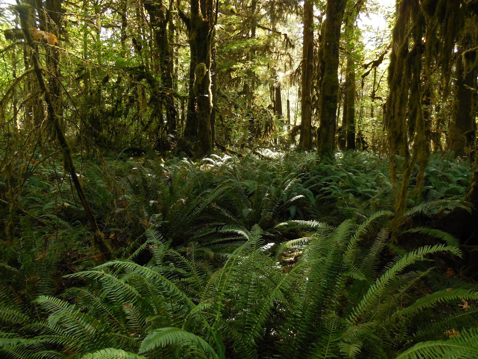
Fern empire on the forest floor.

Moss empire!

Is this some kind of creature?  

Moss even grows underwater here.  This stuff is in a stream in the Hoh rainforest.

Thursday, August 27, 2015

Icefields Parkway

Catching up on blog posts...earlier this month I was in Jasper, Alberta, preparing to cruise the Icefields Parkway through the Canadian Rockies to Banff.  I stayed at Patricia Lake Bungalows, a resort on the pristine lake of the same name.  It's three km or so to Jasper, but out in the wild, with loons calling at dawn and dusk.  Here the Solara is ready for the run.

Sunwapta Falls, on the Athabasca River.  The Athabasca flows strongly all through the summer from the melting of its namesake glacier.  It roars through a gorge here with wild power.

The Athabasca...to me, the name evokes the North.  Rising from the parent glacier, it flows north through Alberta to Lake Athabasca, far north of all the province's cities.  Its waters eventually wind up in Hudson Bay.  Trees on the islands are small because the islands are periodically washed away by floods.

The crow abides.

The massive Stutfield glacier.

Not much climate change debate here in Canada.  They buy into it.  See the next pic for evidence.

Here, I'm walking to the snout of  the Athabasca glacier.  The sign in the foreground marks the position of the snout in 1982.  Now, it's out of sight, over the ridge in the foreground, beyond all the people, about a quarter of a mile distant.  I first visited the glacier in 1972...this place was under ice back then!  

The snout of the glacier.  It originates in the Columbia Icefield, over the ridge in the background.  As I did in 1972, you can still take a sno cat tour on the ice.  But the glacier has shrunk by about half in the last 60-70 years.

An ice cave at the snout.

Glacial runoff.  The edges of a glacier are messy piles of rock...moraines of material carried down from the heights and deposited by the receding ice.

The Lizards do the glaciers!  Not their natural habitat.  They miss the cactus and sagebrush.

Long glacier, not far from Athabasca.

This creek is so full of fine glacial sediment that its waters are virtually opaque...and the color of milk.

Bridal Veil Falls, not far from Athabasca Glacier.

A classic U-shaped glacial valley.  The Icefields Parkway is one of the world's great drives.  The weather was decent the day I was there...had the top down part of the way.  But just a couple weeks later...still in August...snow fell on the peaks.

The Saskatchewan river at Saskatchewan Crossing.  This was a trade route for millennia, first for native peoples and later for European pioneers such as David Thompson, who came through here in the early 19th century and mapped much of North America.

Layers of trees, seeking level ground on the slopes.

The Saskatchewan River, with boreal forest.

Peyto Lake.  NO photoshopping...it really looks like this.

Abstract northern scene at Peyto Lake.

Bow Lake.  Most lakes up in these parts are turquoise.  Will post pics of Lake Louise and Moraine Lake later...equally fine.

Even the Bow River in Banff is bluish green.  This pic was taken from my deck at the Bow View Motel in Banff.  Great location...out the back was the river and a vast expanse of forest.  Out the front...bustling downtown Banff, with Safeway, the Old Spaghetti Factory, an Irish pub, and all the modcons.  Quite a juxtaposition...very cool.

Fine Hike at Mount Rainier

Went hiking at Mount Rainier with my friends Dick and Wilma the other day.  Beautiful day, massive mountain.  The sheer mass of Rainier, and its isolation from other peaks, make it truly outstanding.  Every time I see it up close, "Wow!" is the instinctive reaction.

But, as almost everywhere here in the West, it's dry.  This is Frozen Lake.  Normally it would be much larger and deeper than this, and might even still have a few chunks of ice around.  But not this year.  This is actually an artificial lake, with a dam off to the right.  It's the water supply for the Sunrise area.  Gettin' a little sketchy.  But the season is almost over...Sunrise is closed by October...and precipitation is on the way!

Nice shot of the mountain with a moraine and an alpine meadow.  Some friends hiked up here in late June and the countryside was green with scads of wildflowers...just the way it should be now, two months later.  Flowers are long gone.

Our trail ascended numerous talus slopes.

Volcanic outcroppings, remnants of long ago eruptions.  Looks a bit like Mordor.

Rainier, being so high and standing alone, is a prime spot for the development of lenticular clouds.  A parcel of air, not quite saturated, cruises toward the mountain, rises when it encounters the peak, cools, and condenses into a cloud.  On the other side of the mountain the air sinks, dries out, and ceases to be a cloud.  In the weather business we call these lennies.

Closeup of the lennies and some of the glaciers on Rainier...still massive, but shrinking.

This fire lookout was built in the early 1900s.  There's a panoramic view from here, and though satellites and  other equipment are mainly used to detect fires now, this spot is still used from time to time and has a standard Osborn Fire Finder.

The two lennies have merged.

The valley below, at about 6800 feet elevation, is tundra like you'd find at sea level in the Arctic.

Whitebark pines, hardy trees that grow at timberline throughout the West.

Saturday, August 22, 2015

Stanley Park

The Vancouver paper had a dramatic headling regarding our warm ocean temperatures.

A forest of masts, and of skyscrapers in Vancouver Harbour.  I've started a circumnavigation of Stanley Park.

A little farther along the path...totem poles.  These are modern poles, carved within the last 50 years for the most part.  Some are replicas of older totems.

Girl in a Wetsuit oversees the potash loading operations over in North Vancouver.