Sunday, August 30, 2009

Basin Ramblings


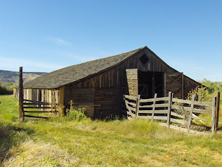
I came home from Sunriver last week via the Great Basin and the Sierra. I picked that route because of the wide open spaces and peace of the Basin, and the spectacular mountain scenery of the Sierra. I rambled thru Southeastern Oregon and visited Pete French's long barn near Frenchglen for the second time. French was a rancher who built a vast land empire in SE Oregon from 1872 to 1897. This barn was built in the 1880s. He used some dubious methods, like buying up land surrounding a farmer's plot and then denying that farmer access to his own land. One such homesteader, Ed Oliver, shot French to death in 1897 after a scuffle. The jury, made up of homesteaders, acquitted Oliver in short order.

Here's the inside of the long barn. Local juniper logs were used in the construction, and they were only minimally shaped, giving the interior a natural appearance. Both times I've been here I disturbed deer who were hanging out in the barn. French also built a round barn some miles northeast of here, designed for breaking horses during the cold winter months. Didn't visit that as it's well off the highway, but I've been there before and it's quite interesting.

An easterner would probably not recognize this scene as Oregon! In reality, at least a third of the state is arid or semiarid, full of sagebrush. They call this area Oregon's outback, and having been to the original outback in Australia, I can say there are close resemblances. You can really stretch your legs in this country. This shot is taken in Harney county, which has about 7600 people in a 10 thousand square mile area, larger than Maryland. Anytime you're in an area with less than one person per square mile, it's fair to say you're Out Bush!


The mighty Humboldt River in Nevada near Lovelock. The Humboldt is not this wide in most places...this part of the river is actually a reservoir. The river is about 300 miles long, but being in the Great Basin, it doesn't empty into the ocean; it just peters out in the Humboldt Sink, southwest of here.


This is Walker Lake, in western Nevada. The lake is the outlet for the Walker River, but in most years water from the river never reaches the lake; unless the adjacent Sierra snowpack is at least 120 percent of normal, the river's water is entirely siphoned off for irrigation. As a result, the level of Walker Lake has dropped 130 feet in the past century! With a maximum remaining depth of only 80 feet, the lake appears doomed to disappear well before the end of this century unless some conservation program for it is developed, as has been done at nearby Mono Lake. Unfortunately, as far as I know no such program exists for Walker.

Tuesday, August 25, 2009

Central Oregon Scenes...plus one


On my way south out of Cle Elum last week, I bypassed Interstate 82 and drove through the Yakima River Canyon on the old highway. It was delightful! Steep walls of basalt and sage; the river running robustly; majestic ponderosas. I found this swinging bridge across the river at a rec site...there are about half a dozen places where you can camp, fish, and picnic in the canyon, which is a little less than 30 miles long.


I probably blogged this last year, but the shot of the South Sister looming over Sparks Lake in central Oregon is too good to pass up. This is on the Ray Atkeson Trail, named in honor of Oregon's premier scenery photographer. I would guess that at some time during his long career
he took a similar pic from close to this spot.

I found this red columbine near Lava Lake, on Century Drive maybe 15 miles past Sparks Lake.


As always, when I stay at Sunriver (near Bend) I visit Crater Lake. On this occasion I had the pleasure of playing tour guide for three folks who had either never seen it at all or had only glimpsed it from the air. They were blown away when they saw it up close for the first time! And why not...it's one of the world's power spots. The deep blue of the lake is mesmerizing. The lake's setting, on top of a mountain surrounded by jagged volcanic rock and gnarly trees, is surreal.


This is a little different look at the lake, along a shoreline adjacent to Mount Hoffman, at about 8150 feet the highest point on the lake rim. I love the jagged, multicolored rock formations here. What you're actually looking at is a bit of the innards of Mount Mazama, exposed when it collapsed about 6800 years ago. The big cliff on the right side of the pic is Llao Rock.

Wednesday, August 19, 2009

Tracking the Ice Age Floods...again

On Monday I traveled south thru Central Washington, following the Ice Age Floods. This massive glacial erratic lies in a field 30-40 miles southwest of Grand Coulee Dam. It was deposited by a huge ice sheet, thousands of feet thick, that dammed the Columbia River and diverted it from its historic (and present) course past Wenatchee. Instead, the river flowed through the Grand Coulee, dozens of miles...and over 500 feet higher! to the east. The ice sheet created Glacial Lake Columbia, which lasted for a couple thousand years and was occasionally inundated itself by the Missoula Floods.


The diverted Columbia flowed over Dry Falls, at the southern end of Grand Coulee. During normal river flow, the river would have cruised over the cliffs on a front perhaps a mile wide and maybe 50 feet deep...impressive enough, probably about like Iguazu Falls in Brazil and Argentina today. But during the Missoula Floods...the scene was tremendous! Imagine a torrent of water at least 300 feet deep, roaring at 60 mph, dropping over the 400 foot precipice with such speed and volume to render the falls a megarapids rather than a cataract! Nothing like it has been seen anywhere in the world since. Between the ordinary flow of the diverted Columbia and several dozen Missoula Floods, each lasting several days, the basalt cliffs in the coulee were eroded about 20 miles back in just a couple thousand years!


On this trip I acquired a new book titled "On the Trail of the Ice Age Floods" One of the highlights of the book was this area called the West Bar, on the Columbia River near Quincy Washington. What this picture shows, incredibly, are flood current ripples. You can see ripples like these in any creek with a sandy bottom...I see them at the beach in Monterey during the winter when little streams...mostly rainfall drainage...run into the ocean. Of course, such ripples are maybe an inch high and a few inches apart. These ripples in the picture average 24 FEET high and 360 feet apart! The flow of water that created these ripples is estimated to have been as much as 650 feet deep. Interestingly, the book theorizes that the ripple flood was not one of those associated with the emptying of Glacial Lake Missoula, but was probably the result of a huge flood on the Columbia River when the Cordilleran Ice Sheet broke and Glacial Lake Columbia emptied at the end of the Ice Age. Blow up the pic for more ripple detail.


These are basalt columns in Potholes Coulee, a few miles south of the West Bar. Water from the Missoula Floods roared westward across the prairie around present day Ephrata and Quincy, and then flowed over a cliff down almost a thousand feet to the Columbia River basin. With the huge volumes of water and the speeds of flow involved, the floodwaters carved the basalt back from the cliffs a good mile in this area. The waterfalls involved, while not as spectacular as at Dry Falls, must have been really massive for a few days during each flood. Just south of this locale is the Gorge Amphitheatre, a famous concert venue located in an area where the highest floods eroded a small canyon in which the Amphitheatre sits. I'd love to go to a show there sometime...Coldplay was there last month just before I saw them near Sacramento.

Saturday, August 15, 2009

Hangin' in the YVR


I did a full day of exploration in Vancouver today. Went for three long walks...the old flippers are draggin' but not too much...I think I'm getting just a bit of conditioning going after hiking almost every day for a week! I started by going into Stanley Park and visiting the Aquarium, which is world class. There are a vast variety of marine critters, from piranhas to belugas to sea otters. Among the more photogenic are the jellyfish.


Here's one of the belugas. I think this is the first time I've ever seen one! One of the whales just had a baby...and yes, you can buy a furry baby beluga in the gift shop. So cute. No, I didn't get one. But it's cool that a baby was born at the aquarium.


I came back to the hotel and rested the flippers for an hour, then walked across the Burrard Bridge to the Kitsilano district, where a street fair commemorating the 40th anniversary of Woodstock was underway. This band was doing a good cover of many of the Doors' hits. The lead singer couldn't quite scream at as high a pitch as Jim Morrison, but sounded like him otherwise; and the lead guitarist was great! Up the street a few blocks another band was covering Neil Young in even better fashion. We all sang along to Rockin' in the Free World...cool!


After an excellent Indian dinner...there are three Indian restaurants on the block across the street from the hotel, all with takeaway...I headed down to English Bay for the sunset. It's kind of a ritual...there are musicians, drummers, and lots of people of all ages chillin' out. The dawgs like it too.


Twilight lingers for a long time at this northern latitude...just south of the 50th parallel. By setting my camera on my balcony railing I got this sunset shot a full half hour after the sun actually dropped below the horizon. Y'know, I have thought for many decades that Vancouver would be an excellent place to spend the summer! The city hums with cosmopolitan energy; the arts thrive here; grazing is superb. And the hinterland...up toward Whistler, east to the Okanagan, west to Vancouver Island...has unlimited outdoor recreation. And it's all gorgeous! It would sure be neat to get a fine apartment in the West End...or in Kitsilano...for a month or two in summer some year. Don't be surprised if I do it sometime!

Friday, August 14, 2009

Green Water, Black Bears


After traveling mostly in wild areas of Canada for a week, I finally got a good look at a bear today...less than a mile from the chic shops, restaurants, and condos of Whistler Village! There is a large park..actually untouched forest...in the middle of the village with many trails for hiking, biking, and jogging in summer, and cross country skiing and snowshoeing in winter. Right next to one of the most heavily traveled paths, I and a bunch of other folks found this bloke grazing in the berries. We had to move slowly and quietly past him, only about 25 feet away, to continue on the path. He snorted a bit when I took this pic but continued grazing. The bear and the rest of Whistler is stoked for the Winter Olympics, which begin in just six months!


A mountain lake northeast of Whistler, with fireweed.

The previous shot is a typical British Columbia scene, but this pic shows standard terrain in the southern interior of the province. Yes, sagebrush and ponderosa pines north of the 50th parallel! This is the Fraser River near Lillooet.


This is Nairn Falls, just north of Whistler. It cuts thru volcanic rock, sending milky light green water racing down a forest canyon.

Wednesday, August 12, 2009

Dawson Falls...Kayaking Anyone?

This is Dawson Falls, in Wells Gray Provincial Park in British Columbia. Cowabunga!!

Wells Gray Waterfalls


I just spent three days in Well Gray Provincial Park, about 100 miles north of Kamloops in central BC. I have seen this huge park...bigger than Holland...on maps for many years and was always curious about it. Now that I'm retired, I tend to go check out these kinds of spots. Turns out Wells Gray is a vast area of pristine wilderness specializing in waterfalls. This is Spahats Falls. It has cut deeply through a weak seam of basalt since the land was freed from glacial ice about ten thousand years ago. Compare this pic with those of Palouse Falls...two posts back...to see a comparison of erosion solely from a rather small stream versus the effects of the humongous Missoula Floods!


Dawson Falls, on the Murtle River, roars over a slab of basalt instead of down through a seam. This cascade is about 60 feet high, and on its south side...nearest the camera...it drops over several steps. I'd be surprised if some expert kayakers haven't run it!


But...any kayaker who makes it over Dawson Falls can't make it all the way to the Clearwater River. Because...Helmcken Falls is in the way! This cascade drops 450 feet. It has a tall main falls, then a little stream run, then a smaller, wider lower falls...similar to Multnomah Falls in the Columbia Gorge.


Helmcken Falls also drops over a thick layer of basalt, layed down over millions of years during many eruptions, just likein much of Oregon and Washington. Just downstream from Helmcken, the layers from different eruptions are especially distinct.

Smoky return to Halcyon


I'm up in Beautiful British Columbia. The license plates don't lie...it's gorgeous up here! Towering mountains, pristine lakes. This is the SS Moyie in Kaslo, on Kootenay Lake, one of the province's most spectacular bodies of water. The Moyie cruised the lake as a working boat from the 1890s til 1958. It's now a museum, moored next to a beach in the funky town of Kaslo. You could travel months in BC and see glorious, interesting country every day.


You might think this pic was taken in coastal BC, perhaps among the Gulf Islands or along the Inside Passage south of Prince Rupert. But this is Kootenay Lake, about 300 miles inland! The lake is as gorgeous as Tahoe, with about one quarter the development. When I shot this pic, I was on BC ferries, which runs a 35 minute free ferry as a part of route 3A across the lake. This is one of the best travel bargains anywhere! You get a fine cruise on a world class beautiful lake for nada! At times in the summer, as when I rode the boat, you have to wait over an hour to board. But, there's a beach and restaurant right next to the ferry landing, so no problem.


I returned to Halcyon Hot Springs, a plush resort on Arrow Lake with four pools ranging in temperature from 55 to 104 F. I stayed here two years ago. You hang out in the pools, soak up the rays, kick back in comfy cabins with views of the lake, and dine at a gourmet restaurant. Not bad!


However, just two ridges over from the springs a rather large forest fire was burning. The previous weekend the resort had been briefly evacuated, but this weekend the wind was light westerly, blowing the fire away from us. But...not the smoke, which settled over the region bigtime on Saturday Aug 8. Go to the posts from June 07 and you'll find a pic with a similar view to this one, but under much different meteorological conditions.


The next day I was taking another ferry across Arrow Lake...actually a wide spot in the Columbia River. Blow this pic up and you can see several smoke plumes drifting up the mountain. And check out the lenticular clouds, products of an increasingly strong, moist jet stream that would change the weather from warm and dry to cool and showery.
Thursday, August 06, 2009

An Ice Age Relic


Palouse Falls in southeastern Washington is a lovely cascade 198 feet high. However, it appears rather insignificant in its huge basin, which is over twice as deep as the falls and far wider than the falls would be capable of eroding, even over millions of years. The secret is that the basin in the picture was carved 13 to 15 thousand years ago by our old buddies the Missoula Floods. The remnants of glacial Lake Missoula swept across this area again and again, every time an ice jam impounding the lake in northwestern Montana broke. An incredible volume of water roared through here, filling and even overflowing the basin, gouging out the basalt in a torrent of rapids of almost unimaginable power.


Just above and to the left of the falls are these towers of columnar basalt. They somehow survived the torrents, but all the rock around them was swept away. The towers seem vaguely Tolkienesque to me.


Palouse Canyon extends south from the falls. The little river in the big gorge wasn't always so insignificant. It completely filled the canyon...and then some...during the largest of the floods. The Palouse used to flow into the Columbia via the Washtucna Coulee to the northwest, but the floods overtopped that coulee and diverted the river southward, over the falls into the Snake.


The basalt cliffs in the canyon are majestic. They formed about 15 million years ago when vast quantities of lava flowed out of the ground again and again, covering much of Oregon and Washington thousands of feet deep. Each eruption produced a layer of basalt...you may be able to see some of the layers if you blow up this pic. The same type of cliffs can be seen in the Columbia Gorge, Grand Coulee, and near John Day Oregon. For that matter, they also make up Devils Postpile in the Cali Sierra.


A good shot of the falls and their basin...also a faint rainbow at the base of the cascade.

Monday, August 03, 2009

Fabulous Mount Rainier


Today we drove up to Mount Rainier. Rainier is the most massive single mountain in the continental US. A few peaks in Colorado and California are a few feet higher, but none stands alone like Rainier. And none has the massive glaciers. And the wildflower display at Rainier in the first week of August is absolutely fabulous!! It is difficult for an old, fat sloat to hike the steep trails on the lower slopes of the mountain, even if I am relatively nimble for my age and girth. But it's worth it, to be in one of the most glorious scenes anywhere in the world!! The pic above is Narada Falls, which flows over a lava bench and leaves a perpetual rainbow on sunny days.
Wildflowers abound in the meadows around timberline.
Here, paintbrushes and lupine thrive under the mountain. The trees are mostly gnarly spruces.
The mountain looms over the landscape. Not only here, but clear to Tacoma, almost 50 miles away!
After a lot of huff puff, and plenty of stops to admire the scenery, we've reached an elevation of 6300 feet, almost a thousand feet above Paradise (which, by the way, holds the world record for most snowfall in a season, almost 100 feet!!) Blow up the pic and you'll see a substantial waterfall just left of center, sending snowmelt under the Nisqually glacier.

Seattle Sojourn


Yesterday I spent the afternoon in Seattle. I'm staying with friends in Puyallup, and they have friends who live in the Capitol Hill district in Seattle. They have a cool old house with a fine green yard and two neat dogs, and own and operate a bar right across the street from their house. Talk about a nice commute! I and my ol' college roommate Dick did a street hike thru the 'hood and found this sequoia a few blocks away.


There's a great variety of trees in the neighborhood. A few yards from the sequoia I found...a palm tree! It certainly wasn't having any trouble on this day...it was about 90 degrees.


The homes in Capitol Hill are mostly nice, and very eclectic. They were mostly constructed in the 1920s, and come in all styles from Tudor to Queen Anne. I love the places like this one with a large wraparound porch.


This is a repeat of a picture I took almost 40 years ago while I was in college at the University of Washington. It remains cool to check out the Space Needle thru the donut sculpture. By the way, while we were street hiking we were treated to frequent flyovers by the Blue Angels, who were in town for Seafair. After the hike we retired to our friends' bar and sampled beers while watching the hydroplane races on TV. It was a really nice afternoon all round. I have somewhat neglected Seattle since graduating in 1973. I get there every five years or so, but that is not nearly enough. I need to visit every year!!