Sunday, May 28, 2017

Olympic Peninsula Interior

My friends and I ventured to Sol Duc Hot Springs, deep in the interior of the Olympic Peninsula.  We had a nice lunch at the resort, earned by hiking up to Sol Duc Falls.  This country is at a higher elevation than the rainforest around Lake Quinault...around 2000 feet.  Snow is more common in winter; the first time I hiked here was in March and there was a dusting on the ground.  No snow this time, but plenty of runoff from recent rains and snowmelt from the nearby mountains.  And sublime light in the forest.

The Sol Duc River courses through the forest.

 A tributary of the Sol Duc has cascades that are somewhat magical.

It's tricky to get the perspective of this shot from the photo.  But, this log has become wedged in a rock slot perhaps 40 feet below the bridge I stood on to shoot this picture.

Turn around from the previous view and Sol Duc Falls is roaring.

The Falls produces a permanent rainbow.

Water, rocks, moss

In places the forest floor is totally mossed in.

This is a pond with a log in it and with many plantsm growing out of the water.

Fairly well hidden deer near Lake Crescent.

Flowers and birches

This maple tree caught our eye.  It's quite a fine tree.  Obviously quite old.

Standing under the maple and looking up.

A fine field of flowers fronting the forest.

Abstract flower closeup.
Lake Crescent broods on a gray, tranquil day.  I have loved this lake for half a century, and finally got to stay here for two days.  Its peace and beauty is sublime.  Good food at the restaurant too!  And rainforest all around.  It's a wonderful spot.

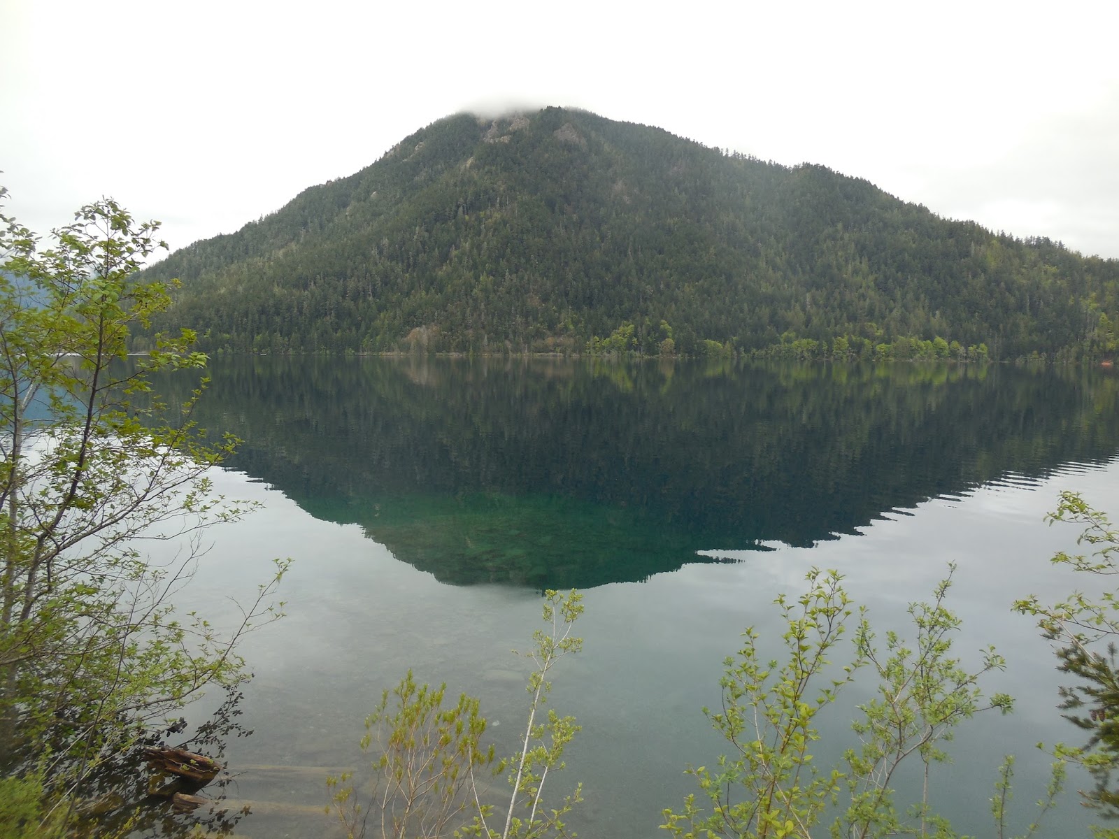
Mountain mirrored in the waters of Lake Crescent.

The Soggy Olympic Peninsula

I recently ventured to the Olympic Peninsula, parts of which are right up with the wettest spots in the continental US.  And, the rain was pouring down as I arrived at Lake Quinault.  The clouds shrouded the mountains and lent an air of mysterious tranquillity to the scene.

A giant Sitka spruce near the lake...one of the largest.

A waterfall rushes through the rainforest.

A trail through the rainforest near Lake Quinault accesses a magical world of lushness.  In the foreground is a swollen though sluggish stream, coursing through the forest.  Blow up the pic and it's evident the rain was pouring down.  I was trekking along with my umbrella.

The Olympic rain forest is the quintessential moss empire.

The rainforest trees grow beards!

Tree silhouettes

Another shot of the remarkable lushness.  A month earlier, I was in the Arizona desert near Phoenix.  Two more different landscapes cannot be imagined.  Each can be rigorous to us humans, but each is beautiful and interesting in its own way.

A mossy tree base.

Within an hour, I had reached the coast and driven out of the rain.  The shore at Olympic NP is strewn with logs, washed out of the rainforest by winter river floods and by storm waves that erode the cliffs backing the beaches, causing trees to topple into the ocean.

Massive stumps lie on the sand, while the living trees are sculpted by the wind.

This tree trunk exhibits massive gnarliness.

And, of course, a classic nurse log.

Late afternoon sun sparkles on the sea.  Destruction Island lies offshore to the left...home of the wind.

Monday, May 15, 2017

Yachats Scenes

Last Thursday in Yachats, rain fell most of the morning, with strong winds before dawn.  It was a cozy storm that made for good sleeping.  By midmorning the rain had decreased to showers and the wind was abating.  The light was good on the shore.

Wind and water have eroded a gap in the soft rock along the 804 Trail, a shoreline path that runs for several miles in Yachats.  The soil above the rock, anchored by thick vegetation, has resisted the erosion.

Onshore winds sculpt the trees...here and along most of the Pacific coast from central California north into British Columbia.

A stream rushes across the beach as clouds billow offshore.

A blowhole fires up.

This Sitka spruce is almost 200 feet tall...it was taller until the Columbus Day Storm in 1962, which blew off the top 30 feet or so.  It is around a thousand years old.

A stream gurgles through the rainforest.

The view from Cape Perpetua, 800 feet above the sea.  No, I didn't hike...there's a road to the top.  Though the south winds had diminished at sea level from overnight gusts of 35 mph or so, here they were still blowing at least that strong.  I imagine they were really rowdy overnight.

Another view from the cape, looking far down the coast toward the south.  A grand spot!

This view from the cape looks toward the northwest.

While the sun shone frequently along the shore last Thursday afternoon, interior mountains were still swathed in clouds and mist.  The wonders of orographics!

Classic shot of Heceta Head lighthouse.  I met an Australian cyclist here who was also shooting this scene.  We started talking about fine coasts we had seen...he said the Oregon Coast was like the Great Ocean Road on steroids!  That's a beautiful coastal drive in the Australian state of Victoria, west of Melbourne.  I've seen it too...it's pretty and spectacular but the Aussie was spot on.

A coastal estuary at Neptune State Park, just south of Cape Perpetua.  The Oregon Coast has countless beauty spots preserved as state parks and waysides, the large majority of them with free access.  It's truly one of the world's fine seashores.

The Fabulous Southern Oregon Coast

Last week I ambled up the Oregon coast in a variety of weather conditions.  The coast changes moods with the weather, but the common denominator is that it is eternally scenic and majestic.  It varies from tranquil to tempestuous, but it's always a fine place to be.  These offshore rocks are near Port Orford.

Most of the beaches are backed by large piles of large logs, evidence of the power of winter storms.

Near Port Orford, trees on the immmediate shoreline are in various stages of disarray.  One or two more storms will turn many of then into beach logs like the ones in the previous picture.

As the morning elapsed, low clouds parted, and the atmosphere changed from brooding to bright as Humbug mountain emerged.

The beach at Bandon.

Sunset Beach near Charleston (OR), not far from Coos Bay.

Near Cape Arago, sloats pack the shore on an offshore rock.

Cape Arago was so beautiful the Lizards chilled and took in the vibe.

Farther north, between Reedsport and Florence, I took a peak at the Oregon Dunes...with blooming rhodies in the foreground.

The dunes on the Oregon coast are not like the ones in Death Valley...it's really wet here most of the year.  So wet that there are numerous lakes scattered among the sands.

I settled in Yachats at the end of the day, between Florence and Newport, about halfway between California and Washington.  I always stay at the Fireside Motel.  Why?  Well, this is the view from my deck.  The fine weather that I had enjoyed for four days was ending, as a storm approached from the west.  

The lowering sun and the incoming storm changed the mood again.  The day that started brooding, became bright, now ended with an ominous beauty.  Rain started after midnight...five days later, it's still coming down.