Tuesday, October 31, 2006

Ode to the whelk


My favorite shell in Florida is the whelk. Observe, and marvel, at the symmetrical lines of these shells. The sluglike critter that lives in the shell is an artiste, composing his home with perfect spirals, sleek, curving lines...a master of design! As you can see, they come in a variety of colors. I have found several live ones, which are even more gorgeous but of course have to be thrown back in the gulf, which is fine. Respect must be shown to the designer! Still, one does this with a bit of regret; I cut my foot on what turned out to be a gorgeous large live shell, maybe four inches long...about twice as long as the shells pictured.

Fighting conchs


The mosaic is just a partial shot of my booty from one morning on the beach at Marco Island. Particularly prevalent were the shells pictured singularly...the Florida Fighting Conch. They are 2-3 inches long and live in the sand in the shallows. For obvious reasons it's illegal to take live shells as we want to keep the supply coming. Even if this were not so, it's not wise to mess with the fighting conch! I first encountered them on Sanibel Island, near here, about 10-12 years ago. Inexperienced as I was, I grabbed the first nice one I saw and stashed it in my bag. A minute or two later I heard thrashing inside the bag. The critter in the conch shell had been deep within his home, and when he figured out he was no longer on the beach he extended a couple inches out of his shell and commenced whipping around in a belligerent manner. Thus the name. Needless to say, I promptly tossed him back in the Gulf and checked all subsequent fines carefully to determine whether they were occupied or not, and only took the empty ones.

Wednesday, October 25, 2006

Genteel Savannah


Savannah is a gracious, leafy city. Huge oaks are everywhere, spreading a canopy of foliage over the streets, with Spanish moss drooping toward the ground. The effect is lush, sensual, humid, and a bit mysterious. Actually, to get the real feel of the city I should come here on a calm, steamy, sticky summer day when everything moves slow and everyone is a little sweaty. Kind of like New Orleans. Today was nowhere close to this atmosphere; dry and chilly...lower 60s at best...it felt more like Seattle or Monterey than the deep south.

The architecture here is different than in Charleston. The buildings shown are typical...19th century, large and many of them done in Federal style. Fancy grillwork is popular. Many were rundown in the mid 20th century, but have been finely restored in a continuing project that begain in 1955.

Savannah has a unique city plan. The city's founder, James Oglethorpe, laid out a grid interrupted by 24 squares, of which 21 survive today. The fine result is that when you're walking in the central city, a lush, shady square is never more than a couple blocks away. They have benches where it's nice to pass the time and enjoy the greenery and passing people.

There are a few irregularities. There is a statue of Oglethorpe, but not in Oglethorpe Square; it's in one of the other squares. Same thing for Pulaski, a Polish bloke who fought for the US in the revolution and died here. He has a nice monument in the center of a square, but not in Pulaski Square. This doesn't seem to bother the locals.

Sherman's HQ


General Sherman used this mansion as his headquarters over Xmas 1864 after capturing Savannah. Fortunately he didn't burn the place like he did much of the rest of Georgia. The general certainly didn't skimp on his hangout, though even this place didn't have cable and wifi back then.

Back in the old 'hood?


This is Monterey Square in Savannah. Since my first visit here in 1999, I've been curious as to why there's a square in this city named after my town when Savannah is much older. The answer, as The Lizard discovered, is that back during the Mexican War Monterrey, Mexico, was spelled differently, (at least by the Yanquis) and this square was named after a military victory in that city. Still, it's kinda cool to find a seeming trace of the old 'hood in such an unlikely spot.

Hunting Island

Ah, what a nice beach! This is Hunting Island, SC. Unlike spots like Myrtle Beach and Hilton Head, this island is almost undeveloped; most of it is a state park. Here are four miles of beach that, as you can see, isn't very crowded. I imagine it's busier on a warm summer afternoon; this was a crisp fall day with temps in the mid 60s; but still, there's plenty of room to roam.
I suppose there are advantages to more crowded beaches; for example, at Manly in Oz, there are many fine sheilas to add to the ambience. But overall, this is my kind of beach where an old sloat can rest his flippers, read, doze, and generally sloat out. Found a few shells here too.
The state park has cottages you can rent that are right on the beach, part of an old style ramshackle beach community. This would be nice to do some day.

Monday, October 23, 2006

Pinckney Island Resident


I went hiking in Pinckney Island National Wildlife Refuge today, next to Hilton Head. Here's one of the locals, a pretty good sized gator who has been swimming in a pond coated with algae. He is hauled out almost next to the trail around the pond, and I and another guy were contemplating whether we should continue on the trail or let the gator have his turf; sympathy was leaning toward the gator, but a couple seconds after I snapped the picture he did an abrupt u-turn and dived back into the lake. Just as well. I reckon he was a bit ornery; it was a cool day for these parts, about 65 with a breeze, so the gator probably was not as energetic as usual.

Hilton Head is pretty and there's a lot to do, but it's heavily developed in an exclusive style; lots of private roads and limited public beach access, especially free public beach access. When you're used to California, Hawaii, and Australia, where most beaches are easily and freely accessible, it's kind of a hassle when it's otherwise. Still, I can walk to a 12 mile long beach from my resort, and that ain't bad.

SC Lowcountry

The area of South Carolina near the ocean is known as the Lowcountry. This is a lush area of waterways, swamps, lazy towns and small cities, and humidity. This shot taken from my car on Edisto Island shows typical landscape; huge trees dripping with Spanish moss overhanging the road. Time moves slowly in most places. Actually on the day I took this picture, Oct 21, there was no humidity and it was a fine top down day. But usually it's sticky.

Friday, October 20, 2006

Fort Moultrie


This is Fort Moultrie, on the mainland at the eastern side of Charleston harbor. There was a working fort of some kind on this site most of the time from 1776 to 1947, from the Revolutionary War to WW II. It was interesting to look at the gun emplacements from the various eras, and another thing; I've wandered around the Marin headlands, seen the old concrete forts there, and all the massive locked gates, and wondered what they originally looked like. At Fort Moultrie, you can! Many of the spaces within the batteries have been restored to their working condition, with ammo in the magazines, desks and old Life magazines (different kind of magazine) in the offices, and guns that have been restored and look new.

The outdoor picture shows some gun emplacements, and the island in the harbor is Fort Sumter, which I visited on my earlier trip here in 1999. There are still cannonballs embedded in the walls at Sumter. The indoor pic is within the fort, and shows a hoist used to lift ammunition from the magazines to the guns above.

The next two weeks I will be staying in timeshares; don't know if they have internet access. If they don't the Old Sloat will be mostly incognito. At any rate, he will be sloating on the beaches of SC and FL much of the time in the next 3 weeks.

Distinctive Architecture


This pink house on the Battery has some interesting architecture. It was built by the Ravenel family in 1847 and remained in their ownership until 1953. I'm pretty sure this is the same family who gave their name to the ultramodern bridge highlighted in an earlier post. The piazza (balcony) was part of the original house...from what I've read the piazza became popular in the 1820s and they were added to many prerevolutionary homes in that time frame. This house was severely damaged in the 1886 earthquake, and when it was repaired it was also renovated with Victorian features such as the overhanging wood trim at the top, which San Francisco street hikers will recognize as a classic Italianate feature in many homes that survived the 1906 earthquake and fire there. Like that disaster, the 1886 earthquake was a milestone in Charleston; homes that survived and were renovated have earthquake bolts and newer places do not. The place I stayed in last night had bolts.

Spooky and Old

Charleston is known as a favorable ghost habitat. This residence is the Thomas Rose House, on Church St., built around 1740. In 1786 a bloke named Joseph Brown Ladd was wounded in a duel, carried to this house, and expired therein. This sort of stuff happened a lot in the 18th and early 19th centuries; famous people killed in duels included Alexander Hamilton (the same bloke on the $10 bill) and Alexander Pushkin, the Russian poet. The bloke who died here wasn't even named Alexander, and perhaps this is the reason his ghost is said to inhabit the premises. Or not.

Monterey gang (ex)


Here's a good shot of the four ex-Monterey forecasters. This was taken on the veranda of Wendy's apartment. We had a nice reunion...have to do it again! To me, it hardly seems like we all left, but here we are in Charleston, almost three thousand miles from Monterey. Wendy and Scott are now severe weather and hurricane experts...Wendy's even certified in upper air balloons! Shawn is learning all the names of the Pacific Northwest Rivers...the Skookumchuck, Stillaguamish, Clackamas, John Day, Snohomish, etc. The Old Sloat is learning about new parts of the country he didn't visit before, and slowly...slooowly...he's learning to use modern hi tech stuff.

Thursday, October 19, 2006

A new Charleston landmark


Though Charleston makes its tourist dime on history, there is also a fine new ultramodern structure in the city. This is the Ravenel Bridge, spanning the Cooper River between Mt Pleasant and Charleston. It was just completed in 2005, and crosses the river very gracefully with two towers secured by symmetrical cables. It's especially cool to drive it in a convertible with the top down as I did today. It's already one of the signature landmarks of the city, a nice contrast to the old historical buildings. (thanks to Scott, who was driving so I could shoot the picture).

Washington Slept Here

When I was a kid, long ago, there was a standing joke that every spot in the east with a modicum of history bragged that "Washington slept here". I don't hear this joke much these days, but here's a place where he actually did crash, on a presidential visit to Charleston in 1791. This is the Heyward-Washington House, built in 1770 by Thomas Heyward, a signer of the Declaration of Independence. It says something for a bloke's stature that all he has to do is hang at a place for a day or two to get his name on the house along with the owner's.

Ex-Monterey forecaster reunion


As is appropriate in Charleston, where everyone except Rhett Butler is social (he was not received in Charleston society) The Old Sloat has been social here. We've had a meeting of folks from several weather offices, from coast to coast! From left to right, we have The Old Sloat, ex- Monterey: Wendy, ex-Monterey, now Charleston: Shawn, ex-Monterey, now Portland OR; Scott, ex-Monterey, now Newport NC; and Bob, Wendy's colleague in Charleston. All four of us ex-Monterey people have bailed in the past year, and here we are getting back together in Charleston, of all places! For the past three days we and a number of other local weather folks have wined, dined, boozed, dined, skulled beer, and dined. It's been fun! Rhett should have been so lucky.

Tonight I'm kicking back by myself watching game 7 of the NLCS and it's nice to relax, but I guess we should be partying some more. I thought I reserved an ordinary motel room at the Best Western here, but they put me in a suite! It's in one of the old, long Charleston buildings so there's a large kitchen, then a spacious living room with a bar and fireplace, then a nice bedroom, all in a row. Very luxurious!

This is my second visit to Charleston; the first was in 1999, and each time I have really gotten into the city and really enjoyed it. It's a distinctive place, like San Francisco, Vancouver BC, Sydney, London; it's smaller than those other cities, but equally unique and attractive. One of my places! It's beautiful, historical, and there's a lot of great restaurants. It rocks!

City of churches


Charleston is famous for its magnificent historic churches. When you cruise out on the harbor, the prevailing highlights of the skyline are the graceful spires of churches. There are many of them, and no modern skyscrapers to intrude on the scene. This is St. Philip's Episcopal Church, built between 1835-1838. There was a church on the same site before, but it burned in one of several big fires in the late 1700s and early 1800s. The graveyard next to the church is interesting to explore as some of Charleston's leading citizens are interred there.

Street hiking in Charleston


Charleston is a fabulous walking city. It oozes history and charm. There are many architectural styles, some of them quite rare, at least in America. There's a lot of cool landscaping. And...it's flat! Anyone can walk it. This picture shows Chalmers Street, the city's longest remaining cobblestone street, first laid in 1760. The pink house was built about 1712 and was a tavern in prerevolutionary days. The cobblestones are very uneven and somewhat difficult to walk on, especially when you're drunk...so I imagine there were some mishaps hereabouts in the 1700s.

Wednesday, October 18, 2006


This is Wendy's house in Charleston. Actually she wanted someplace with a little more room but there was nothing on the market.

In fact, this is the Calhoun mansion, built in 1876. I am making a major correction to this entry; unlike the original comment, it was not the home of the prominent South Carolina politician John Calhoun; he died in 1850.
Nonetheless, it's quite impressive; 24 thousand square feet (not hundred, thousand!), 35 rooms, all with fireplaces and 14 foot high ceilings. Wouldn't want to clean it!

Sucking up the humidity in Charleston


Charleston is a fine old city, dating from 1680, with elegant homes, some overlooking the waterfront. Many homes have spacious piazzas, which is what they call balconies here. The home in the background of this picture has a fine one. Charleston is as distinctive a city as San Francisco; elegant, historical, cosmpolitan, more liberal than the surrounding territory. It's great for walking; many buildings have plaques on them explaining their history, which dates back before the Revolution in some cases. It's just a great place to explore and hang out. The weather is distinctly un-San Franciscan; warm and sticky much of the year, including today. The humidity adds a langourous atmosphere to the scene.

Monday, October 16, 2006

Old Monterey forecasters and friend


Here's a couple old Monterey forecasters hangin' out in Carolina with the ol' houn' dawg. It's nice down here! We have a guest blogger today!

Well, one of the Monterey forecasters is older than the other. I have many many years to go before I retire and take a major boondoggle like Steve. It is great to have him visit the coast where the water is warm, it's the middle of October and the water is still 68F. Everyone is invited to come visit, there is lots to do from kayaking, clamming, eating great seafood (mostly fried in the south but we can grill our own), touring lighthouses, or just chillin on the beach.

Ocracoke


Here's a shot of beautiful downtown Ocracoke. You can only get to this island by ferry or airplane or private boat, so it's quite remote. There is some tourist activity, but not much on a Monday in October. It looks like a good place to go troppo for a few days and just hang out at the beach and consume seafood and adult beverages.
By the way, this was the first palm tree I saw on my journey south! I'm not in New England anymore, y'all.

Cruising the Outer Banks

Here's a gorgeous pic taken on the 7 AM ferry from Hatteras to Ocracoke Island. This was a peaceful, serene trip with calm water, mild air, and obviously gorgeous scenery. The outer banks are spacious, with vast beaches and few people, especially out of season. You really feel like you're at sea; to the east, the Atlantic stretches to infinity. To the west, Pamlico Sound seems to do likewise; the mainland is about 25 miles away, and the terrain is flat, so you can't see land in either direction.

Another plus is that you see beautiful sunrises over the ocean, and beautiful sunsets over the sound. It's really quite nice.

I stayed at a motel right on the ocean with a superb view of the surf. There was a fine deck where you could skull a drink, eat chips, and enjoy the ocean. Also a fridge and a microwave; wish I could have stayed a week! This time of year you can rent a large house with an ocean view, a pool, and a pool table for about a thousand a week or even a little less. Reckon I'll do that one of these years.

I can fly!


This unimpressive looking spot is where aviation history was made when the Wright brothers made the first powered flight on Dec 17, 1903. They made four flights that day, each marked by a stone in this picture. The first flight went up to the first stone, a distance of 120 feet; the airplane was in the air 12 seconds. I can throw a frisbee that far!

When you think of it, it's quite amazing that in a period of just 66 years, we went from a 120 foot flight to the moon! More than a few people, born from the 1870s to the early 1890s, remembered both events! Wilbur died in 1912, but Orville lived until 1948, long enough to see jet fighters. I wonder what he thought about that. Wouldn't be surprised if he was stoked! When the brothers made their first flights, this area was mostly sand; the National Park Service has planted it in grass to stabilize it.

Saturday, October 14, 2006

The posts today should be the last ones without the annying blurry area at the bottom of the pictures. I went to the local Circuit City in Charlottesville this afternoon and bought a new camera, so starting tomorrow I should have crisp images again; and I will train myself to use the wrist strap so I don't drop the camera again! The new camera is 6.2 megapixels compared to 5.1 for the old, so it should be a slight upgrade.

TJ's Crib

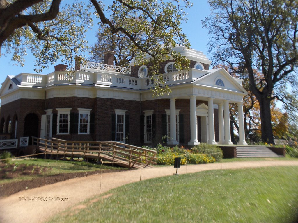
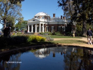
Visited Monticello, Thomas Jefferson's home, today. I had been interested in seeing it for 30, 40 years or so. It proved as fascinating as I had anticipated. The house is not particularly ostentatious...the rooms are fairly small...but it's comfortable and very innovative. For example, there are skylights, unheard of in the U.S. 200 years ago but fashionable in France...Jefferson was a Francophile from his years in Paris in the 1780s when he succeeded Benjamin Franklin as the U.S. ambassador to France.

At Monticello TJ also had storm windows; sliding glass doors; dumbwaiters; and a writing device with two pens connected to each other by wires and pulleys, or something. When Jefferson took one pen and wrote a letter, the other pen copied what he was writing onto another sheet of paper. Pretty good for a bloke who didn't have an HP copier or even an old Xerox! He had a unique sleeping arrangement where his bed was in an open alcove between his study and his bedroom. If he got out of bed to the left, he was in his bedroom; if he exited on the right he could go straight to letter writing in his study.

By his own admission, Jefferson was addicted to reading. He wrote something like 20,000 letters a year. He accumulated a library of 7,000 volumes, one of the largest in North America two centuries ago. And, he took weather observations faithfully every day at dawn and 4 PM for many decades. Indeed, he has been credited with starting the move toward establishment of a federal weather service due to his detailed observations and his scientific interest in weather. He determined the average growing season and annual precipitation of his region with precision.
I reckon that Jefferson and I would have gotten on well!

Although Jefferson was a world renowned scientist, politician, and author during his lifetime, like the rest of us, he was fallible. Though he ran his plantation diligently, he didn't make money and was about $100,000 in debt when he died...the equivalent of 2-3 million dollars today. Though he claimed to detest the institution of slavery, he owned an average of about 200 slaves and only freed two of them during his lifetime, and five more in his will. And DNA testing of the descendants of both families indicate that he almost certainly fathered a child by one of his slaves, Sally Hemings, in 1808, and probably fathered more children with her as well. On the other hand, in 1808 he had been a widower for 26 years, and he was 65 years old! His situation here engenders a certain amount of sympathy on one hand and admiration on the other.

Friday, October 13, 2006

More leaf peeping and a four state run


Yes, I was leaf peeping again today. Two weeks ago the leaves were up in Vermont. Now they're brilliant down in Virginia, at least at 3000 feet above sea level, where this picture was taken. Here in Charlottesville, the trees are a long way from peak yet...we're only about 500 MSL.

For many years I had noted on the Rand McNally that one of the places where you could whip thru a bunch of states in a hurry was on I-81 from Pennsylvania thru the Maryland and West Virginia panhandles into Virginia. Today, for the first time, I got to check it out. The timetable...810 AM, cruising thru Pennsylvania. 811, entering Maryland. 822, into West Virginia. 844, welcome to Virginia! Four states in 34 minutes! Average speed was 0-5 miles above the limit, no more than ten, so obviously some of my friends could do it more quickly, probably in less than half an hour: for example, a certain bilingual UH grad whose first name is the same as the two states just south of Virginia.

Shenandoah


Went to Shenandoah National Park today en route to Charlottesville. The road thru the park, Skyline Drive, runs 105 miles thru beautiful forests, mostly deciduous. There are frequent overlooks, and the views go down half a mile to the Shenandoah valley on the west and the Piedmont plateau on the east. Of course this time of year, the leaves are gorgeous, even if my camera remains on the fritz.
There was a real taste of winter in the air today. Though it was bright and sunny, it was no warmer than 50 degrees up on Skyline Drive, with a cutting wind in many areas. Very crisp.

Thursday, October 12, 2006

The bloodiest day


The battle of Antietam is considered to be the bloodiest single day in American military history. On Sep 17, 1863, almost 23,000 troops on both sides combined were killed, wounded, captured, or went missing. Wikipedia cites 3,654 men killed. This is roughtly a thousand more than we have lost in 3 1/2 years during the fiasco in Iraq! These casualties occurred at a time when the combined population of the US and the Confederacy was about one tenth of what it is today, so in modern terms 36 thousand troops would have to die in one day to equal the carnage. And in three days at Gettysburg, 7,700 troops died. The Civil War was rough, man!

This picture depicts the Sunken Road, also known as Bloody Lane. As you can see, the road lies below the surrounding terrain, due to heavy use and erosion in pre-Civil War days. The Confederates positioned lines on the roadbed against Union troops attacking from nearby ridges. This doesn't sound like too good an idea to begin with, but it became catastrophic when the Yankees outflanked the Confederates and obtained an open field of fire right down the road! Can you say ducks in a shooting gallery? Contemporary photos show Confederate bodies stacked in heaps along this road.

Incidentially, I accidentially dropped my camera on the concrete this morning (klutziness from the Old Sloat) and most pics seem to be blurry at the bottom. If this problem doesn't clear up soon I will buy a new camera.

Antietam


The roadbed in this picture is the last sight hundreds of Union soldiers saw on Sep 17, 1862 as they tried to cross this bridge over Antietam Creek before being shot down by Georgia marksmen stationed on the ridge above. The other pic shows a side shot of the bridge from just above the Georgians' positions, so you can see the southern boys had an easy shot. The Yankees tried to take the bridge for four hours, but failed until the 51st Pennsylvania regiment came on the scene. Their commander, a teetotaler, had taken away the regiment's whiskey privileges as a disciplinary measure. Now he asked them to make an effort to take the bridge. The troops said they'd do it, providing he resumed their whiskey rations if they succeeded. He said yes, they took the bridge in a few minutes, and they had their hooch back!

Incidentially, two somewhat notorious generals participated in this battle on the Union side. One, Ambrose Burnside, commanded the troops trying to take this bridge, and it quickly became known as Burnside's bridge, as it is to this day. Burnside lives on in the language. He sported huge muttonchop swathes of facial hair on both cheeks. These became known as "burnsides", but soon thereafter the terminology was reversed, giving us today's sideburns.

Another figure at Antietam was Joe Hooker, known as "Fighting Joe". Hooker had a mix of military and political ability, both of which were perhaps compromised somewhat by his love of whiskey and women. He was a notorious partier and had as camp followers a number of prostitutes. I had heard that since these women were part of Hooker's entourage, the general's name eventually became slang vernacular for ladies who play for pay. However, Wikipedia insists that the term was being used as early as 1845, well before Hooker became famous. On the other hand, his notorious love of partying may have popularized the term. The Wiki folks do verify Burnside's place in the English language.

Wednesday, October 11, 2006

A soldier's life

From a modern middle class viewpoint, it's really amazing what the soldiers in the Civil War went through. For starters, they routinely had to march 10, 15, 20 miles a day dressed in wool uniforms in the heat of a southern summer. Yeech!! No LL Bean or REI boots, either; in fact, at least on the southern side, sometimes the troops had no shoes at all. Food was bad more often than not. They had coffee, sometimes, but it was often lousy; same for booze.

Bathing was an issue. When there was a stream near an encampment and it wasn't too busy, yeah; otherwise no. On cold nights the soldiers often slept in a pattern called spooning, where they laid in a c-shape pressed against one another so their bodies would provide heat to each other. Now the Old Sloat reckons that this would not be bad if his spooning partner was an amiable Sheila sloat who had recently bathed. But if the prospective partner was a crusty Bloke sloat who hadn't touched water in a week, well, no thanks. And no thanks again!

And we haven't even gotten to the combat! Troops on both sides went into battle with no protection whatever; no helmets, no body armor. In many cases they just marched into the other side's guns, hoping enough people would survive to overrun the enemy line. As I mentioned elsewhere, in the 1860s the connection between wounds and infection had not yet been made. Surgeons sawed off mangled limbs without wearing gloves, much less masks. There was chloroform, so the wounded had some anesthetic, but overall medical practices were extremely primitive compared to the present day. What misery! Every time I read about the Civil War, I admire... and pity...the people who fought it.

Little Round Top


Little Round Top is a small but distinct hill that was on the far southern part of the line between the Union and the Confederates at Gettysburg. The panoramic picture shows the view from the top of Little Round Top down to Devil's Den, the rocky area at the upper left. Though the Federals held the high ground at Little Round Top, the Den, held by the Confederates, also had plenty of shelter in the large rocks there. The two sides spent a lot of time sniping at each other. The sites are 500 yards apart, but both sides had rifles that were effective out to 1000 yards, so the sniping was a lethal problem.

The Confederates launched many attacks on Little Round Top. It was the absolute left flank of the whole Federal line at Gettysburg, so a succesful Confederate attack could have thrown the Federals' entire battle order into disarray. Perhaps the Rebels' strongest attack was aimed at the far left flank of the Federal line on the hill. A strong regiment of Alabamans made repeat attacks on the 20th Maine, which held the position under the command of Colonel Joshua Chamberlain. Chamberlain, a mild mannered schoolteacher from rural Maine, was told to hold the line at all costs...and he did. But eventually his troops ran out of ammunition, and the Alabamans were still coming. So Chamberlain did the unexpected...with ammo gone, he charged down the hill into the trees you see in the picture, routed the Alabamans, and held the line for the Union. Imagine the scene. Thousands of good ol' boys are coming after your ass, hollering
the rebel yell; shot and musket balls are whizzing all around you; you're exhausted; it's hot; you haven't had a bath in a week. So...you charge!! Massive cojones, I reckon! And it worked. And for the Alabamans to repeatedly charge up the hill into the Federal guns, lotta guts there too. Pretty amazing.

Chamberlain was later promoted to general, and led his troops through the rest of the war. He was seriously wounded, but survived the conflict, went back to Maine, and became, I believe, the governor. Or a senator. He lived another 51 years after Gettysburg, until 1914; when he finally died well into his 80s. His Civil War wounds were listed as the cause.

The peak of the battle


This memorial marks the place where General Lewis Armistead fell mortally wounded. A lot of people were mortally wounded in the Civil War... infection had not yet been diagnosed as a serious problem and there were no drugs to treat it. Many soldiers died from wounds months or even years after they were injured. At any rate, Armistead led his troops from the woods in the far distance clear up to the ridge where I took the photo; his signature gig was to carry his hat on the tip of his sword during a charge as a beacon to his troops. He fell at the farthest point Confederate troops reached in their attempt to break the Union lines.

One of Armistead's closest friends, Winfield Scott Hancock, was a general on the Union side, leading troops in the same sector! Though they never saw each other during the battle, Hancock was apparently only several hundred yards from his friend at the climax of the fighting. Hancock and Armistead became friends when they were at West Point decades before the war...such relationships were common between Union and Confederate officers.

High Water Mark


It's a little hard to gain perspective of the terrain in this picture, but this is the decisive part of the battlefield on the third day at Gettysburg, July 3, 1863. The Confederates attacked from the woods in the distance...you can see the Virginia monument just in front of the trees. From there was launched the famous Pickett's charge. 12,000 confederates moved out of the woods, over the open ground, and up the slope in front of the rock wall that is visible in the foreground. The slope is not steep but it's well defined...the Union forces had the high ground. When the Confederates approached within range, they were shredded by Union artillery.

Gettysburg Local


I was hiking in the bush on the battlefield and came upon this bloke. Unlike the Joisey bear the day before, the racoon obligingly posed for his picture.


This is a statue of General James Longstreet, Lee's favorite general whom he called his "old warhorse". Notice that the statue is not on a pedestal, and it's in a secluded area off the main road. This hints at unpretentiousness on the part of Longstreet. Reminds me of John McLaren, the primary architect of Golden Gate Park, who hated statues and when forced to put them in the park located them in low key sites. His own statue in the park likewise has no pedestal.

Longstreet was uneasy about Lee's strategy at Gettysburg, but he obeyed orders and committed his men as directed. Though he was considered an outstanding general, he had mixed results at Gettysburg. Lee, a standup bloke, took the blame for the defeat, saying "it was all my fault". I've heard he was not feeling well at the time of the battle, and that may have affected his judgment.

Gettysburg


There are so many historic sites at Gettysburg that it's impossible to blog them all in one...or six...evenings. I'm a Civil War buff...not a radical one but I have a lot of interest in it and nothing compares to visiting a battlefield and seeing the terrain, and the challenges and advantages it presented to both sides.

If you think about it, the Civil War was unusual. On one hand, men slaughtered each other en masse during the battles...but when there were truces the Yanks and Rebs cooperated to move their dead from the field. During the winter, they even sang songs to each other across the lines, and traded goods that were in short supply on one side or the other. And after the war, after each side had killed hundreds of thousands of men on the other, there was an almost universal amnesty as the country began the difficult job of reconstruction. How do the losers in most civil wars usually fare? They usually get shot, or thrown in jail with the key thrown away. But, by and large, that was not the case in our Civil War. Most likely that was a good thing, but very unusual in the context of world history.

This picture is of a statue of general Robert E. Lee, topping the Virginia monument at Gettysburg. Lee was regarded by everyone on both sides as a class act. Just before the war started, Lincoln offered Lee command of the Union forces. Lee replied that he could not forsake his state, Virginia, so despite a distinguished military career in the U.S. army he opted to join the Confederate forces. The monument is near the site from where Pickett's charge originated.

Tuesday, October 10, 2006

Old Newport Real Estate


This is the oldest house in Newport. The plaque says it was built in 1690 but that date was altered from 1670 so I'm not sure exactly how old it is, but it's even older than the Old Sloat!
This structure was about two centuries old when Commodore Vanderbilt constructed his "cottage". Newport in general is a cool tourist town...we in Monterey know the drill...nice shoreline, plenty of pubs and restaurants, lotsa shops, some tacky, some upscale. There are lots of fine old residences aside from the cottages. Rhonda and Al said the place hasn't been quite as popular since they lost the America's cup. It resided here from the 1850s until the 1980s...it was bolted to its podium in the local yacht club, such was its permanence...the Newport yacht always beat all comers. Until the Aussies scored a major upset in the early 1980s and carted the cup off to Perth! After that Dennis Connor, who had lost the cup, regained it for the U.S. but by that time he was based in San Diego instead of Newport so the cup went there. Since then the Kiwis have won it a couple of times and it's now held by the Swiss, who don't even have a seacoast! They will be defending it next year in the Mediterranean.

Newport


I wanted to buy this place but they wanted 50 mil and I wouldn't go a dime over 45. Alas. Actually, this is Cornelius Vanderbilt's summer "cottage" in Newport RI. There is a fine cliff walk of over three miles along the shore that provides a good workout and a view of the cottages. Other cottages are less pretentious than this one...most of them probably have less than 100 rooms!

Greetings from Joisey!

This picture was taken about 75 miles from New York City, in New Jersey, of all places. Notice the throngs of people and the rampant development. We're in the Delaware Water Gap National Recreation Area, and it was one of the prettiest, most peaceful places I've seen in the East! For 40 miles, I cruised along backroads near the Delaware River, through beautiful forests, past peaceful farm fields.

I did have one encounter with a Jersey local. As I was plodding along with the top down (beautiful day) a black bear loped across the road not far in front of me! There was no traffic, so I stopped the car in the road near where the bear had gone into the bush. He stood up to take a look at me in my car, maybe 50 feet away, so I lined up a shot; but an instant before I clicked the shutter, the bear dropped down into the bushes and I never got another good look at him. I did take a picture but the bear was not visible. But...who would think that the only bear I'd see so far on the trip would be in...New Jersey?! Actually it's cool that bears live in the woods less than a two hour drive from Manhattan.

Monday, October 09, 2006

Twain's Crib


This is Mark Twain's house in Hartford. He lived here with his family from 1874-1891 and wrote some of his greatest works here, including Huckleberry Finn. I didn't take the house tour, but saw an exhibit of his works and possessions and many of his sayings. He was an original political humorist and always amusing. Huckleberry Finn has, ironically, been banned at various times over much of the U.S. both because people thought it was racist (no good!) and because they later realized it was militantly anti-racist (?) At any rate, anything he wrote tends to be entertaining, insightful, and humorous. A good combination! For the 1870s, I thought his house was ahead of its time...it had many decks and balconies to enjoy the fine weather, like today...October 9, upper 70s!

Attention Suzanne


Rhonda has a vintage Mini Cooper! This vehicle is a 1977 model acquired from an English bloke who was shipping them over from England...to finance his education if I recall properly. The steering wheel is on the right side but Rhonda drives it around the congested byways of RI with proper expertise.

New England wanderings


Rhonda and Al have a Caribbean Room in their house...filled with tropical plants (even a palm tree! ) as a deterrent against the New England winter. There is a life sized iguana in the room, and I reckon Lizard found himself overmatched in this case!

New England Sunsets


Although the East Coast by definition is more of a sunrise coast, if you access the right topography you can also see some marvelous sunsets (The Aussies might call them ripper! or beaut! Here are a couple examples. I stayed at a place in East Boothbay, Maine, that was built out over the water (at high tide...11 foot tidal difference at the full moon. The shot from there is the one with the boat. This was in a very tranquil location, miles from even the nearest secondary highway. At dusk it was absolutely peaceful.

The shot with the rock was taken from the deck of my friends' Rhonda and Al's extremely fine home on the east shore of Naragansett Bay in Rhode Island. The rock is about 100 feet offshore and serves as a fine tide indicator. At high tide it's barely underwater; at low tide it's well out of the water and the cormorants hang out on it. Sunsets are sublime here too. There is a lighthouse in the middle of the bay; boats cruise past; otherwise it's very quiet. Al grilled not just steak, not just chicken, not just salmon last night...but all three! An absolute first rate feast. Rhonda and Al are both veteran fitness professionals, and they're good influences on me. For two days, I ate NO CHIPS of any kind...and didn't even miss them! I think I'm losing weight. On Saturday Rhonda hiked me into the dirt and then some...just like she used to do when she was my aerobics instructor at San Mateo in the '90s...but it's good for me. (as long as I do nothing tonight and recover!!)