Wednesday, September 27, 2006


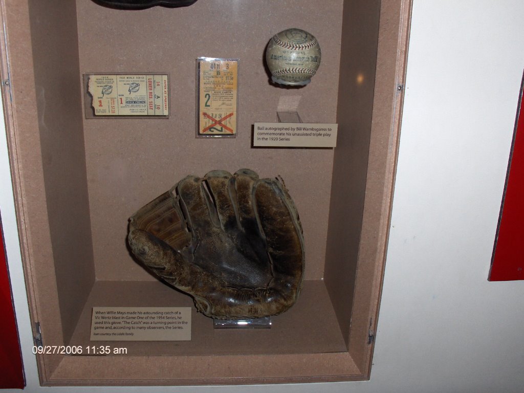
I guess most of my friends aren't Giants fans, but dammit, I am, despite their year end collapse in '06. This exhibit has Bobby Thomson's hat and shoes that he wore when he hit the pennant winning homer in 1951 at the Polo Grounds. The lumpy object to the right of Bobby's hat is the rosin bag used on the mound by Ralph Branca, the pitcher for the Dodgers who gave up the home run. As it turned out, Thomson and Branca became good friends, and have toured the country together as the tandem immortalized in '51. They're still both going strong, serving as ambassadors of baseball.

Baseball Immersion


I'm currently in a very cozy large cottage room just north of Cooperstown, NY on the shores of Otsego Lake. A beautiful setting, with a large body of water nestled in hills beginning to flash fall colors. I'm watching the Yankee game (they're taking batting practice against the Orioles...13-2 in the fifth) reading the New York times. Here in upstate New York it's quite peaceful...you'd never know that one of the world's largest metropolises is only a few hours southeast of here.

Fulfilled a lifelong dream today by going to the Baseball Hall of Fame. Spent 4 1/2 hours there and it seemed like one or two. The exhibits were fascinating. They have everything! For example, the glove pictured here is the one Willie Mays used to make The Catch in the 1954 World Series off Vic Wertz's long drive to centerfield at the Polo Grounds. The baseball above it was used in the only unassisted triple play in World Series history, turned by Bill Wambsganss of the Cleveland Indians in 1920. Back then the baseballs had seams colored both blue and red, instead of just red. (Trivia) At the hall I saw Cy Young's uniform; a century old baseball card of Honus Wagner worth several hundred thousand dollars; Babe Ruth's uniform...and his bowling ball!? Ruth's 60th home run ball, Maris' 61st, and Ty Cobb's Philadelphia A's uniform with no lettering on it, just an elephant. I also read every hall of famer's plaque. I could go on, but suffice to say every baseball fan should see it. Having been a fan since 1959, I was long overdue.


This is the Pine Creek gorge, also called the Grand Canyon of Pennsylvania. It's about 800 feet deep here, 1400 at its deepest point farther south. Nice hiking all around here. The path visible near the bottom of the canyon on the right side of the creek is an old railroad bed converted to a trail. Notice that this is a recurring theme in the east and the midwest. A Westerner notices that there are a lot more railroads here than in the west, and there are many more that have been abandoned, then converted to bike/hiking paths in very scenic areas.

Monday, September 25, 2006

The Yawk


Here's a shot of the Youghiogheny River rushing through its gorge in SW Pennsylvania. This is a major rafting river with up to at least class 4 rapids. It's a very comfortable area with lots of forests and wild country, yet a good supply of funky country stores and lodgings. There are hundreds of miles of hiking trails in the area...79 in Ohiopyle SP alone. Also, you can tour Frank Lloyd Wright's signature home, Fallingwater, less than five miles from Ohiopyle. It's very relaxing here, a diverse recreational area a pleasant day trip from Pittsburgh. Lots of campgrounds if you want to stay longer.

To date, I have driven 3216 miles, but none today. The Vehicle remained in its parking spot at the Crowne Plaza while Nancy, a native, navigated us thru the convoluted streets and roads of Pittsburgh and environs. It was a nice break.

Sloatin' at the Yawk


My friend Nancy wanted to take a picture of the Old Sloat engaged in some rock slotation at the Youghiogheny (yaw-ki-gay-nee) River in Southwestern PA. Like the Katy Trail, there is a long path, over 50 miles, built on an old railroad grade, mainly along the river. It's superb for hiking...we walked about 6 miles today, a nice workout but pleasantly flat...or biking.
The countryside is bucolic...lush rolling and green, with deciduous forests just starting to flash a bit of red and orange, tidy farms, and neat old towns with antique shops and B and Bs. It's very pretty and relaxing, only an hour from Pittsburgh.

Saturday, September 23, 2006


You have to blow up this picture to appreciate it. This is another covered bridge in Illinois, with a sign detailing tolls for various parties wishing to cross. Even swine have to pay...but there is no toll for sloats!! So I crossed the bridge with impunity.


My planned route through Illinois consisted of about 150 miles on I-70, achievable in three hours or less even with a gas and/or rest stop. However, about two thirds of the way through I got tired of battling the legions of slow trucks and fast SUVs, and I noticed that the old highway, US 40, paralled I-70 almost the whole way. So I bailed off the interstate onto 40. This road is a National Historic Trail; it was actually the first interstate highway, built about 200 years ago to open up the growing western parts of the young U.S.

It's a gem! Outside the towns, you cruise along at only about 10 mph slower than on the interstate, and there are NO TRUCKS and very few other vehicles! Follow the historic trail signs and you go through the towns, which are museum pieces of tidy old homes and Civil War era downtown buildings with ornate trim and arcades. At one point the signs led to this covered bridge, on the old old highway...built even before the current two lane US 40. You make good time on the interstates, but you see the country on the side roads. You hear stories of people driving cross country in three or four days. WAY too fast. I've made it only to Indiana in nine days, and will eventually take almost three weeks to reach Maine. Better, but still too fast...six weeks...or six months!! would be ideal.


Yesterday, this Californian visited California, Missouri. Today, this native Portlander (Or) visited Portland, Missouri! It's a very small, sleepy, old town that used to be on the railroad, and is now a trailhead for the Katy Trail. Like Portland, Or it's on a major river, in this case the Missouri, on the right. This is a typical trailhead, with plenty of free parking, interpretive signs describing the trail and the history of the region, and restrooms. From here you can set out for miles in each direction...almost to Kansas City or St. Louis.

I like Missouri. This is my fourth visit here, and the woodsy, rolling landscape, the sense of history, and the leisurely pace of life are really quite pleasant. You can hang out here for a long time, visiting wineries, exploring the old towns, hiking, biking, or just relaxing. Though there are no large mountains or ocean beaches, there are plenty of lakes and rivers, and if you want to pick up the pace a bit, Kansas City and St. Louis fill the bill.


Leaving Jefferson City this morning, I headed east on state route 94, a mellow route running along the north bank of the Missouri River. Parallel to the road is the Katy Trail, a remarkable pathway over 200 miles long built on an old railroad right of way. Though primarily a cyclists' trail, it's also a paradise for hikers and part of it is open to equestrians. It encompasses history, geology, peaceful farmscapes, forest, and the wildlife of the area...there's something for everyone. Very cool. In this picture, the trail goes over an old railroad bridge. For info, see

www.katytrailstatepark.com

Friday, September 22, 2006


After driving east from California for a week, I arrived in...California! It's a robust town of 4000, the county seat of Moniteau county. It's even on US 50, which of course starts in Sacramento and passes by Lake Tahoe.

Thursday, September 21, 2006


Here's a quintessential shot of the Kansas Prairies. A truck scooting by on the interstate, with brooding clouds looming over the cornfields. The beauty of Kansas is not spectacular like southern Utah or the Sierra, but the sense of space and openness one gets is invigorating.


This picture was taken the day before the snow in the Colorado Rockies. The aspen are already magnificent. If you're ever in this area during the latter half of September, seek out the aspen. The trees quake gently, and it's like gold confetti shimmering in the breeze. Hang out in a grove of autumn aspen, and the light is almost like one might imagine heaven to be; soft and golden, peaceful and beautiful.


The Lizard and Toro are doing a little rock climbing in Utah here. Actually I think the Lizard was looking for real live female members of his own species, but no luck.

Capricious Colorado Weather


7 AM, Thu Sep 21. After six days of almost perfect weather, the capricious Colorado climate has struck. The cold front I outran yesterday caught me overnight and now there's an inch of snow on the ground here in Dillon, in the Rockies at about 8500 feet. I must admit its pretty...the trees are laden with white...but for driving it's not too good. The roads here in Dillon are just wet but there's probably slush up at the Eisenhower Tunnel on I-70 (known to locals simply as The Tunnel, spoken with a slight connotation of dread) so I'll wait a couple hours before heading out.

Travel is somewhat of an art, and good travel involves good planning and good decisions. Though the Old Sloat is an experienced traveler, like everyone else he makes mistakes from time to time. But my major error so far would have been quite unpredictable. The Old Sloat forgot to pack t-shirts!! The only short sleeved shirt with lettering I had was the one I wore. Those who know me will most likely be astounded at this fashion faux pas. I will gradually correct the gaffe by purchasing t-shirts along the way...I got two nice ones in Bluff. But...quite an egregious error!

Wednesday, September 20, 2006


Here's a comprehensive shot of the Sipapu Bridge.


Wanted to throw in a pic of the Goosenecks, also in SE Utah. This is the San Juan River, winding an amazingly sinuous course thru the rock and almost doubling back on itself. If it does, cutting thru the rock to join itself, thats when a natural bridge is formed. SE Utah is a geologist's paradise!


I have a couple traveling companions who hitched a ride. There's Lizard. His awkward pose is due to the fact that he's normally a rain gauge...He holds a calibrated glass tube but the tube is packed away. He was originally going on this trip solo but I picked up Toro on a bottle of wine at the new Safeway in Carmel on the way out. Toro is diminutive but can be spotted by the wild sash he wears. His name is just as generic as Lizard's but Toro is definitely a Spanish bull since he came with a bottle of Spanish wine!

In this pic the boys are checking out one of their all wells in Kern county near Bakersfield.
(recommended travel music for this stretch of road...The Eagles' greatest hits! Good road music with a nice country twang.

Natural Bridges National Monument


These pictures are from Natural Bridges National Monument, in SE Utah. There are three large rock bridges, all carved from rock through the eons by streams moving through canyons. There are trails to the bottom of each bridge from the main road through the monument. These pix are from the trail down to Sipapu Bridge, the largest of the three. It's 268 feet long and 220 feet high; 31 feet wide and 53 feet thick.

The trail down is short (0.6 mile) but steep (500 feet elevation loss). The folks who built it had to be rather innovative. The photo of the ledge with an overhanging rock...well, the ledge is the trail! If you blow up the photo you can see a wooden bridge at the end of the ledge...you go down that to continue on the trail. Something like the Anasazi did, I reckon...though I bet their ladders weren't bolted to the stone.


In the canyon below the ledge, I couldn't help thinking that the underside of the arch looked like a dinosaur's belly and neck given the huge size and the stripes. The stripes, I believe, are desert varnish, caused by many centuries of water runoff and seepage.


The picture of the ladder going up the ledge to the handrails...that of course is the trail! Quite an interesting and adventurous hike...highly recommended. It reminds me of the Hidden Canyon trail at Zion, which also has chains, ladders, and staircases.


Southern Utah is spectacular! There is an awesome mixture of incredible scenery, made up mostly of bizarre and wonderful rock formations of all colors; ancient history; wide open spaces; and peace and solitude. To the left is a picture of the Butler Wash ruins, west of Blanding. The Anasazi lived here about 700-1000 years ago, abandoning the site around 1300 AD.

As the wider view shows, the dwellings of the Anasazi were not easily accessible off the freeway exit! Indeed, it looks like they risked their necks every time they left home or returned. They must have had ladders to access the communities tucked into these massive rock enclaves on the sides of the cliffs. Amazing! They must have had a very insular existence...for one thing, if you weren't in shape, you didn't leave home! Archaeologists have speculated on why the Anasazi built their cribs in such inaccessible locations, and the obvious answer is that there were folks around that didn't like them, and whacked the Anasazi every chance they got. So the Anasazi built easily defensible homes.

Saturday, September 09, 2006

Early settlers in the Sierra


This is the summer home of Hale Tharp, one of the first white settlers in what is now Sequoia NP. Tharp lived here each summer from 1861 until 1890, herding sheep in the adjacent meadow. (John Muir wasn't a fan of sheep in the Sierra; he called them "hoofed locusts"). Tharp vacated this spot when Sequoia became a national park in 1890...at the time he was in his early sixties. The rumor that he left because he couldn't get cell phone service is untrue. As you can see (especially if you blow up the photo) Tharp's home is made from a hollowed out Sequoia log. Inside there's a table, cot, and a fireplace. Cozy, if a little drafty.


This is the Grizzly Giant, a massive and finely gnarled Sequoia in the Mariposa Grove in southern Yosemite.
Some of the Giant's branches would make respectable trees in their own right. One of the first people to explore and publicize this grove was Galen Clark. He came here in 1853, 39 years old, given six months to live by doctors who diagnosed tuberculosis. Clark himself was a little more optimistic...he thought he had about a 50-50 chance of survival. Well, he didn't- he died, 57 years later, in 1910, four days short of his 96th birthday! At least for him, and Tharp, who lived to 84, the Sierra was a healthy place.

Friday, September 08, 2006

Looking up at a giant Sequoia.


I went to Sequoia National Park and the surrounding country right after Labor Day...a perfect time to travel! Weather's good, crowds are gone. Stayed at the Buckeye Tree Lodge, as usual. It's in Three Rivers, just a quarter
mile from the southwest entrance to the park. The lodge is right on the Kaweah River, and the rushing water is refreshing on a hot day...you can go sit on a rock and dangle your feet in the river while enjoying happy hour. There's also a pool which hits the spot after a scenic if dusty day of hiking.

As for the Sequoias, their power and majesty has inspired me for 33 years. I started going to the park when I was in the Navy, and the totally different world in the Sierra...compared to San Diego...was always a wonderful change for me. I still enjoy the refreshing air of the mountains; the grandeur of the massive trees; and the peace of the wilderness.
As you can see on the picture to the left, Sequoias are naturally resistant to fire. Their bark is very thick...up to 31 inches if I recall...and the trees contain a great deal of moisture. Even hot fires usually don't kill the tree...they may scar the bark or even scour out the inside of the base of the tree. However, the Sequoia usually just goes on living, even if the bottom fifty feet or so of the tree are hollow. Over centuries, the tree will grow bark around the fire scar to repair the damage.


Here's a picture taken from the deck at the Buckeye Tree Lodge. The Kaweah River is in the background. Bears frequently poke around here. My neighbors saw one at 630 AM one morning when I was there...he was just across the river from us.


This is the Kaweah River at the Lodge from a fine basking rock. Check out the rocks...some are at least as large as a van! Where do they come from? Well, there are similar rocks on the hillside above the river...some probably roll down from time to time. But others most likely are washed downstream from the Sierra during floods. The river is much larger and runs much faster with spring snowmelt and during warm winter rainstorms falling on top of snow. I reckon it's powerful at such times!