Thursday, September 25, 2008

A Surprising Sky Island
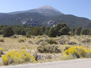


Yesterday, after several hundred miles of sagebrush, my wanderings took me close to Great Basin National Park in eastern Nevada. Having never been here, and having several hours of spare time, I decided to take a look. This is the view I saw upon entering the park. Here I'm at about 6500 feet elevation, looking at Wheeler Peak, another 6500 feet up. Let's go see what's up there...


Well, the top pic doesn't show it, but I saw several bands of gold up in the mountains from below. Sure enough, the aspen were peaking! Just a few miles away from endless sagebrush, Great Basin NP is an island in the sky, sheltering forests of pine, fir, spruce, and aspen. During the ice age, 15 thousand years ago, the area's climate was colder and wetter, and these trees lived on the valley floors. But as the weather warmed and dried after the ice age ended, the trees...and a lot of other plants and animals...were forced to retreat up into the surrounding mountains. Today they remain there, isolated from similar mountain habitats by miles of sagebrush flats. For naturalists, these sky islands are especially fascinating because they harbor many endemic species. Golden aspen don't fit into that category, but they sure are beautiful!


There are quite a few red aspen in the park. Yesterday, it was just fabulous; crisp, clear air, cruisin' with the top down, breathtaking beauty. Great Basin is a gem! About 80 thousand people visit this park annually, compared with 4 to 8 million at the famous parks such as Yosemite, Yellowstone, and Great Smoky. And you know what? It's just as beautiful here as anywhere! I'll be back soon to engage in further exploration.


Up close, a photo of the aspen looks like something Van Gogh...or maybe Jackson Pollock...would paint. Great Basin is fabulous!! Joe Bob says check it out. Check out the following post for more surprises!

REALLY Old Trees!!


Not only are the aspens near their peak fall splendor in Great Basin NP, there are Bristlecone Pines! Yes, here on this sky island live some of the oldest things on earth...not just trees, anything! One tree here is the world's oldest living tree...4,950 years of age! The bristlecones live at timberline, in a harsh environment characterized by cold, wind, poor soil, and drought. As a result, they get really gnarly.


Bristlecone bark is mother nature's Picasso application, coming in all shades and shapes. It's gorgeous...what else can I say? As a hiker I met on the trail remarked, everyone should see these trees before they die. Blow up the pic for more detail.


One reason bristlecones live so long is that part of the tree survives after other parts are long dead. The right side of the tree in the center gave up the ghost probably centuries ago, but the left side is still going strong...blow up the pic for more detail. Core samples taken from the log lying in front of the tree reveal that it was three thousand years old when it died three hundred years ago. Bristlecone wood is very hard and has a high resin content. Combined with the dry climate, it doesn't rot...rather, it erodes slowly, like rock.


Bristlecone pines don't have a monopoly on timberline vegetation in Great Basin NP. Limber pine also grows here; you might recall that this hardy pine also grows among the lava at Craters of the Moon NM in Idaho. In this pic limber pine is on the left, bristlecone to the right.

Lizards in Their Element!


The Lizards absolutely tripped out in Capitol Reef. Here they are exploring a niche in the sandstone. They love to hang out on rock, the more convoluted the better!


Slickrock abounds in Southern Utah. It's great for hiking or mountain biking, or for just engaging in horizontal slotation in a wild, beautiful environment. At this spot, the lizards and I enjoyed the slickrock for at least an hour...could've stayed all day. Slickrock sloatation and granitic sloatation are of course very similar...both are wonderful wilderness experiences.


Here our saurian friends are simply hanging out in their natural habitat...the desert. I have been exploring the American west for almost a month and a half now, and it amazes me that there are so many beautiful and fascinating things to see and explore. Name any western state, and I could stay there all summer and not remotely run out of things to check out and enjoy. We westerners really are fortunate to live in such a favored part of the world! The same superlatives apply to western Canada as well.

Sandstone Erosion


Southern Utah's scenery is based largely on erosion. Most of the rock is soft sedimentary, with sandstone predominant. A good 150 days a year feature freezing and thawing. If a little water wedges into a seam in the sandstone, the freeze/thaw cycle forms amazing patterns in the rock. Hole patterns such as this are not unique to this area; you can see them in many other places, including Uluru (Ayers Rock) in the Australian outback.The result is surrealistic art.


In addition to erosion, shifts in the earth's crust have tilted many of the sandstone layers...but not all. The result is stratified rock lying at crazy angles. More surrealistic art.


This is a common pattern in the canyons of Capitol Reef. Water collects in a seam between layers of sandstone. When it freezes, it expands in pockets all along the seam. The result is a straight line of holes in the rock.

Capitol Reef Rock Art


The rocks in Capitol Reef NP come in all shapes and colors. Roaming around the park, I was blown away by the beauty and variety of the landscape. It's a harsh environment...warm and dry, or cold and dry, usually...except for the odd flash flood. The occasional bit of lush vegetation and the colors of the land provide a nice contrast. This is an example of desert varnish on a canyon wall.


Though the rock comes in many colors here, the predominant hue is RED.


Today, there is a hiking trail in Capitol Gorge. A century ago, this was the main east west route through the Waterpocket Fold; today's route, highway 24, wasn't built until 1962. Some of the pioneers carved their names in the rock. These inscriptions are at least twenty feet above the canyon floor; someone must have had a ladder. Blow up the pic for more detail.

Wednesday, September 24, 2008

Cool Rocks in Utah


Utah is one of the most colorful states in the union. The landscape is profuse with rocks of all colors and degrees of hardness, which results in complex erosion and a myriad of shapes and hues. The scenery is always spectacular, and very interesting. Clouds add depth to the scene. These towers are in south central Utah, between Green River and Hanksville.


You frequently see contrasting scenes such as this; a mellow, well manicured pasture in a river valley, backed by a harsh, jagged, beautiful rock formation. This is west of Hanksville.


Adding to the allure of the land are the legacies of civilizations that were here in the past. The area has been inhabited for about ten thousand years, give or take a millennium or two. Each has left its mark, from prehistoric pottery to petroglyphs like these, to orchards first planted by Mormon pioneers in the late 19th century. These figures are in Capitol Reef National Park. Blow the pic up for better detail; the petroglyphs are just about in the center.


Much of the rock in these parts is sandstone, formed by countless layers of silt over millions of years. The rock has different chemical compositions, which determine color and hardness and result in fantastic shapes, hues, and forms. Geologic forces have raised, lowered, and tilted the rock formations, and weather has done the sculpting. This is in the Waterpocket Fold in Capitol Reef NP. Google Waterpocket to find out how this feature developed. It's about 100 miles long, cut by deep canyons. I'll blog them probably tomorrow. Cap Reef is a gorgeous place, harshly beautiful and spectacular, and not too crowded. This was my first visit for longer than an hour or two.

Fall in the Colorado High Country


Spent last weekend in the Colorado Rockies; rented a condo at Breckenridge. It's beautiful in the Rockies year round, but especially in the fall when the aspen turn. I was a little early; traditionally the last weekend in September has the best color and I was there a week before that. Still, there was some good color. There are a few of the prized red aspen in this shot.


September is a hybrid month. In addition to fall colors, there is still some summer convection. Colorado has the coolest clouds in the nation, most likely a result of the steep topography combined with access to moisture from the Gulf of Mexico and the location of the jetstream, which is usually over the state. I usually try to leave utility poles out of my pictures, but in this case the line of poles standing against the glowering sky was cool. Blow up the pic for more effect.

Wyoming Wanderings


This picture was taken in Central Wyoming. Today it's very quiet here. There are ranches, jackrabbits, antelope, and rattlesnakes; not much else. The highway I'm on is a secondary route. But a century and a half ago it was actually much busier here. The Oregon Trail ran through this valley, and carried thousands of emigrants from the east to the west in the mid 19th century. In 1860-1862 the Pony Express galloped through here...there was a station in the valley where riders changed horses. Native Americans, trappers, and traders also used this path. No Burger Kings back then (or now) hereabouts, but the Sweetwater River runs through the valley and that made this a good travel route.
I would guess that most Californians don't know what this is. It's a snow fence! These are de rigeur along Wyoming highways, where the wind howls incessantly...especially strong in winter and spring...and blows snow over the landscape like shifting sand. This fence is along Interstate 80, which is in one of the worst wind corridors in Wyoming. When the freeway was built 35-45 years ago, there were no snow fences and the road was routinely closed by ground blizzards in winter and spring. Back then, it was known as the "Snow Chi Minh Trail". The local folks soon installed miles of these fences, which catch snow just to the lee of the structures, and prevent much of it from blowing onto the road. Highway closures decreased substantially after the installation of the fences.

Monday, September 15, 2008

A Perfect Hike!


I hiked about seven miles in Grand Teton NP today, and it was one of the best days I have EVER spent on the trail. Everything was ideal. The scenery, as this post and the following one show, was awesome. The weather was perfect...a crisp morning followed by a warm afternoon, with sunshine and only a gentle breeze. No mosquitoes...only a few flies of no consequence. The hike was a proper workout for an old sloat; fairly long but almost dead flat. The trail was neither crowded nor empty...I encountered a few dozen congenial folks along the way but had plenty of space to myself. It's probably better to not be on a deserted track in bear country. In mid September, fall colors were beginning to shine. And, the piece de resistance...Leigh Lake turns out to have white sand beaches! This is almost too good to be true for a beach bum like myself. This pic shows a really cool island in the middle of Leigh Lake with exactly one (1) tree, and a robust one at that.

Here's the view from my spot on the beach. I stayed here for over an hour, reading, dozing, and soaking up the beauty. It was superb! Hiking to a beauty spot like this and then finding a fine beach, a thousand miles inland, is like going to a casino and winning a jackpot while playing with house money!


Here's a lengthwise shot of one of the best beaches on Leigh Lake. This pic was taken in late morning; by mid afternoon the entire strip of sand was in the sun. Just a perfect spot for horizontal solar slotation!


The lizards also enjoyed chillin' on the playa. Here they're perched on a log, contemplating Mount Moran.


Fall foliage provides endless opportunities for abstract pictures. Just find a blend of colors, shapes, and shades, and you have a cool piece of art.


Awesome Mountains


I've been visiting Grand Teton National Park for the first time ever. My bad! For twelve years I lived in Denver, and for much of that time I had a schedule that, once a month, enabled me to get off work at 8 AM Thursday and not return until 4 PM the following Tuesday. Why I never drove up here during that time is beyond me! But, on this occasion the Venerable Pinniped was able to correct a mistake, and I finally made it up here. It's breathtaking! The mountains soar above the landscape, towering, jagged, primeval. There are three large lakes at their base...Jackson (pictured here), Jenny, and Leigh. It's absolutely gorgeous!


Jackson Hole is over 6000 feet above sea level, and skies are crystalline much of the time. This was certainly the case when I was there. The mountains were sharp...especially early in the day when the easterly sun clarified the peaks, as in this shot.


This is Mount Moran, at the northern end of the Tetons. Of particular note on this peak is the black band of basalt near the summit, known as the Black Dike. This rock was wedged into the mountain by volcanic forces after the peak had originally developed. The patch of ice near the dike is the Skillet Glacier. Near the summit, the Black Dike actually protrudes outward from the rest of the mountain; blow the pic up for more detail.


I took a bunch of Teton pics today...can't blog all the good ones. This is a sample, taken at Leigh Lake. To be honest, although I enjoyed Yellowstone...it's beautiful, interesting, and diverse, it didn't knock my socks off. Grand Teton NP does. So do Yosemite, Crater Lake, Mount Rainier, Hawaii Volcanoes, and Craters of the Moon. Next time I visit this area...which will be soon...I'll probably stay more days around Grand Teton than Yellowstone.

Sunday, September 14, 2008

Surreal Scenes in Yellowstone


I've spent the past two days in Yellowstone NP, my first visit there since 1971. Yellowstone is diverse; it features canyons, waterfalls, wilderness, beautiful mountain lakes, and lots of large wildlife including bear, moose, elk, wolf, and bison. But Yellowstone is probably known most for its vast concentration of thermal areas; geysers, hot springs, boiling mud pots. There are more thermal sites here than anywhere else in the world. Most of the park sits in a vast caldera, the remnant of a massive volcanic eruption about 650, 000 years ago. There is still a lot of subterranean heat here, and water from rainfall and snowmelt that percolates downward taps that heat and reemerges in a variety of forms. The result is very artistic; the landscape takes on a unique blend of colors, shapes, and textures.

The hot pools and geysers here are dynamic. They emerge, disappear, strengthen, weaken on a regular basis. This is also a major earthquake zone and each quake rearranges the thermal structure of the region.


The colors of the water depend on its temperature and chemical composition. They can change from season to season. This pool and the one in the picture above are near Old Faithful. I didn't see the famous geyser erupt, but the surrounding area was fascinating.


This is Castle Geyser, near Old Faithful. This geyser also erupts on a regular basis, about every 13 hours. Unlike many other geysers, Castle has been in operation for thousands of years, thus its large cone that has built up from mineral deposits. Blow the pic up and you can see bison in the background. Though thermal areas are roped off as unsafe for humans, the critters like it here, especially in winter; areas around geysers and hot springs are warmer and more snowfree than other parts of the park, so elk and bison have an easier time foraging for grass and other goodies on the perimeter of the thermal fields.


Here's a juxtaposition of a thermal pool, the Firehole River, and in the background (blow up the pic) more bison. The Firehole has extensive thermal input so I'm sure it has warm spots along its course. Look closely in the pool and you can see some logs. The pool probably grew in size over the years and swallowed up a bit of forest.

A Canyon as Artists' Palette


The Grand Canyon of the Yellowstone looks like a work of modern art, with various colors splashed across the rock at random. The colors are caused by thermal features within the canyon, which send water of varying mineral content flowing down the walls.


Combined with the colors are diverse rock formations, ranging from round to jagged. There are throngs of tourons at Artist Point, but hike just 500 to 1000 meters up the canyon rim trail and you leave virtually everyone behind, and you can enjoy the splendor of the scene in solitude.


The climate here is rigorous. Subzero winter temperatures contrast with hot summer sun. Wind is strong, snow can be heavy, but rain is often sparse. Still, limber and ponderosa pines tough it out. Blow up these pics for more detail.

Yellowstone Cascades


Yellowstone is full of waterfalls, though none match the height of those in Yosemite. On the other hand, they flow year round...except that they freeze into icefalls in winter. This is Fairy Falls, a couple miles from the road near Old Faithful. It's about 200 feet high. This appears to be a complicated waterfall. Part of the flow is coming all the way from the top of the ledge, but upon close examination it looked pretty certain to me that another part of the flow is coming out of the recess in the cliff about halfway down the falls. Blow up the pic to study the falls. It appears there is an underground stream paralleling the aboveground branch. The 1988 fires burned right up to the edge of the water.

This is the upper fall of the Yellowstone River, in the Grand Canyon of the Yellowstone. It's about 100 feet high and thunders even now in mid September, at the time of minimal snowmelt and the end of a fairly dry summer.


Here are the lower falls, only about a mile downstream and about 300 feet high. This picture is from Artist Point, and was taken in late afternoon on a sunny day, which is the wrong scenario. It's much more colorful if you shoot this scene in the morning, preferably with clouds obscuring the sun. When I was here in 1972 the conditions were much better and the scene was breathtaking.


Gibbon Falls are only 84 feet high, but are very picturesque as they cascade sinuously down the canyon.

The Old West


Blow this picture up and you'll see a scene straight out of the Old West. Down on the Yellowstone River are hundreds of bison (many more than in this picture), grazing tranquilly by the water, with no civilization in sight. There are many hundreds of bison in Yellowstone...I saw probably 500 in two days so I reckon there are most likely at least a thousand in the park. The only sign of human activity in this area is not pictured...massive traffic jams caused partly by bison on or next to the road and mostly by tourons who stop their vehicles in the middle of the highway to gawk at them. Other tourons get out of their cars to photograph the bison at close range and are then injured by the critters, who tend to be curmudgeonly.

This is about as close as I want to get to a bison. The pic is taken with a zoom feature, and there's a stream between me and the critter. Given those features, he stays mellow.

Friday, September 12, 2008

Welcome to Mordor!


I visited Craters of the Moon National Monument for the first time today. I had expected it to be interesting, but probably not amazing, since I had been to Hawaii Volcanoes NP many times...also to Haleakala. But I was blown away by Craters! It's a landscape of amazing beauty, wildness, and complexity. Anyone who is a Lord of the Rings fan will recognize this landscape...Sauron would love it here! The amazing thing is that this a'a lava is two thousand years old, and still virtually nothing has grown on it. The climate here is continental and dry, with six months of freezing nights, hot summer days, and only about ten inches of precipitation per year. In many places the lava looks as fresh as if it had flowed 20 years ago instead of 2000. Spatter cones are in the background. Most of the lava here flowed out of fissures that extended at least 50 miles across the Snake River Plain.

I've taken tons of pahoehoe pictures over the years, but none since I started blogging...until now. Pahoehoe is hot, viscous lava that often flows rapidly. A'a is much more chunky, and often impassable on foot. It results when lava cools and flows more slowly than in its pahoehoe state.


This pic shows a'a on the left, pahoehoe on the right, and blooming sagebrush in the foreground. Couldn't find that in Hawaii! Blow it up for more detail.


This is a shot of Big Crater. As usual, the wind was blowing from the southwest when it last erupted, so the northeast side...to the center and right of the picture...is higher due to the greater volume of volcanic debris deposited there. Various minerals and chemical compositions account for the different colored rocks in the crater. This area has seen no volcanic activity in the past two thousand years but the rift zone is still considered active and will most likely erupt again. Who knows when? could be next year, or a few millennia from now. I have over forty pictures of Craters that I liked...can't blog them all. Suffice to say it's an amazingly beautiful and interesting place. There are many hiking trails and I'll be back to explore the place in more detail.