West Coast Wonders
 I have done a leisurely homeward trek over the past eight days, and have seen many fine things. I have not been in a city with over a hundred thousand people, and have driven less than two hundred miles on the interstates. This appears to be a tranquil wilderness forest; but it's right in the city of Bend! Central Oregon's metropolis (population 80,000, up from 12,000 in 1960) has preserved a lot of open space as it has grown. Bend today is a mecca for outdoor sports enthusiasts in fields including skiing, rock climbing, cycling, hiking, golfing, white water rafting, and many more.
 Tumalo Falls, only about 15 miles west of downtown Bend. A popular wilderness destination.
 As at Multnomah Falls, if you hike to the top of Tumalo and then go a bit farther upstream, you find several other fine cascades.
 The view from the deck of my room at the Riverhouse in Bend. You fall asleep to the rushing sound of the Deschutes, which drowns out the traffic noise on Business 97 very nicely! This tranquil spot is in the middle of the city, within walking distance of the forest in the first pic. Bend has a fine network of hiking/biking/cross country skiing paths.
 Had a crackling thunderstorm in Bend Sunday night, with a nice rainfall. The next morning these mammatus clouds appeared near Sunriver.
 Now I and the Lizards have advanced to Crater Lake NP. The Lizards are inspecting the pumice field, still inhospitable to tree growth seven millennia after Mount Mazama blew its top.
 Crater Lake is a power spot. Whenever I visit...and I go almost every year...I find a place away from the road, with a view of the lake, and just chill for awhile. I'm not the only one who does this.
 Crater Lake lends itself to surreal scenes. Here the tour boat is cutting a wake across wind blown ripples.
 Phantom Ship. Blow the pic up and you can see a tour boat. The boat is 40 feet long...the island, appearing small, is actually 180 feet high and 500 feet long!
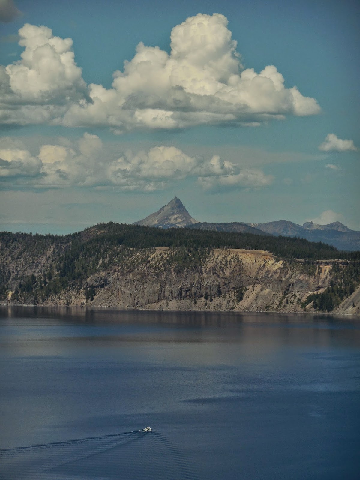 Cumulus congestus build over Mount Thielsen, to the north of the Lake.
 This morning I explored Ashland. I have probably driven by this city on I-5 20 times in the last 50 years without getting off the Interstate and taking a look. So, this time I stayed overnight and investigated. Here I'm in Lithia Park enjoying a huge Jeffrey Pine. Jeffreys look just like Ponderosa pines, but you can tell them apart by their cones..."Gentle Jeffrey, Prickly Ponderosa". You can hold the Jeffrey cones in your hand and grip them fairly tight...the spines point inwards. Try that with a Ponderosa cone and you'll regret it...their spines point out...into your skin!
 Ducks out for a morning swim in the upper duck pond at Lithia Park. It's a gem...designed by John McLaren, the main sculptor of Golden Gate Park in San Francisco.
 And on to Burney Falls, in Northern Cali. Blow up the pic and you can clearly see that the falls get their water from two sources...a surface creek that splits at the precipice, and from underground springs! Much of the water that goes over the falls flows below ground level, between two basalt layers, the bottom one less porous than the top, until the water reaches the cliff edge. In fact, the water from the creek (the two largest cascades) often also flows underground until about a mile upstream from the falls, when it surfaces from subterranean chambers. Burney Falls is most unusual!
 Here the Lizards are contemplating Lassen Peak from Lake Helen, 8000 feet above sea level. The first time I visited here, in early July 1967, the lake was still frozen! Now the region is in the midst of a drought and snow and ice are long gone. How long will the drought last? Well, the Southwestern US had a 220 year drought and another one lasting 140 years between 1000 and 1500...with a 100 year wet period in between! Precipitation is dicey in these parts.
posted by oldsloat @ 9:37 PM
0 comments
![]()
![]()

0 Comments:
Post a Comment
<< Home